- Home
- Assessments
- Bioregional Assessment Program
- Pedirka subregion
- 1.1 Context statement for the Pedirka subregion
Executive summary

The context statement brings together what was known about the geography, geology, hydrology and ecology of the Pedirka subregion as at July 2015.
Geography
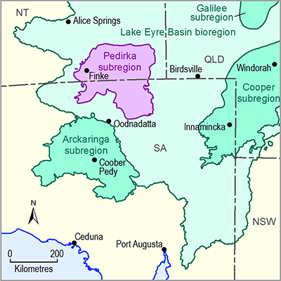
The Pedirka subregion spans the Northern Territory and South Australia border, approximately 160 kilometres south-east of Alice Springs. The subregion spans an area of about 75,760 square kilometres and is located entirely within the Lake Eyre drainage catchment. The subregion is generally flat and arid with highly intermittent streamflow. Groundwater is the principal water supply.
The subregion is sparsely populated with approximately 240 people located in the township of Finke and with the remaining population spread between pastoral homesteads and Indigenous outstations. The Traditional Owners and custodians within the subregion include the Lower Southern Arrente, Andegerebenha and Wangkangurru peoples.
Pastoralism, with a focus on beef, is the major land use with tourism also being important.
Geology
The boundaries of the Pedirka subregion are based on the Pedirka Basin, which is overlain by the Great Artesian Basin. The Pedirka Basin is a subsurface sedimentary basin comprising Early to Late Permian sediments and coal sequences which formed from 252 to 298 million years ago. The Pedirka Basin spans approximately 71,000 square kilometres.
As at July 2015 no commercial exploitation of coal seam gas was underway in the Pedirka Basin, although some exploration work has been undertaken. The basin is also the subject of conventional hydrocarbon exploration.
Surface water and groundwater
The Pedirka subregion includes the southern and downstream section of the Finke River basin, much of the northern section of the Macumba River basin, and the southern extent of the Hale River. Assessments of surface water – groundwater connectivity in the Pedirka subregion have identified the lower Finke as an important recharge zone for the Great Artesian Basin. The Finke catchment contains some permanent waterholes; the Macumba does not.
The behaviour of groundwater within the sedimentary Pedirka Basin is poorly understood and it is unclear if the formations act as single flow systems or as separate discrete aquifers.
In the vicinity of the Pedirka subregion there are two recognised main aquifer units within the Great Artesian Basin: an upper aquifer, the K aquifer, and a deeper aquifer, the J aquifer. The J aquifer is the only regionally extensive water resource of generally fresh to brackish water in the Pedirka subregion.
Ecology
The Pedirka subregion is in Australia’s arid zone where highly variable rainfall and low soil fertility are the dominant environmental drivers. The Great Artesian Basin Springs, located in the south of the subregion, provide one of the few consistent water supplies for aquatic species. These springs have flowed continuously for between one and two million years. The wetlands of the Finke River support a diversity of waterbirds and wetland plants, many of national significance.

- 1.1.1 Bioregion
- 1.1.2 Geography
- 1.1.3 Geology
- 1.1.4 Hydrogeology and groundwater quality
- 1.1.5 Surface water hydrology and surface water quality
- 1.1.6 Surface water – groundwater interactions
- 1.1.7 Ecology
- Citation
- Acknowledgements
- Contributors from the Government of South Australia
- Contributors to the Technical Programme
- About this technical product
