Summary
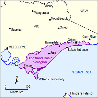
The geological Gippsland Basin covers an area around 46,000 km2. The basin widens and deepens to the east and about 70% of the basin occurs offshore beneath the present-day continental shelf. It is bounded to the north by Paleozoic basement rocks of the Eastern Highlands, to the west by uplifted Lower Cretaceous Strzelecki Group fault blocks of the Strzelecki Ranges, and by the Bassian Rise in the south-west which separates it from the Bass Basin. The Gippsland Basin began to form in the Early Cretaceous in response to rifting between Australia and Antarctica around 150 Ma.
Within the Gippsland Basin there are three major stratigraphic groups: the Early Cretaceous Strzelecki Group, the Late Cretaceous to Eocene Latrobe Group and the Oligocene to Pliocene Seaspray Group. Deposition of each of these groups was preceded by a major tectonic event resulting in erosional unconformities that define the base of each group and are presumed to be continuous across the basin.
The Gippsland Basin is Australia’s premier hydrocarbon basin, hosting very large oil and gas reserves that supply gas markets in Victoria, NSW and Tasmania. These reserves are found in the Latrobe Group sediments. The Gippsland Basin also hosts some of the largest brown coal deposits in the world within the Eocene to Miocene age Latrobe Valley Group coal measures. These coal measures are mined for electricity generation for the Victorian market. The Gippsland Basin may also be prospective for coal seam gas and tight gas hosted within the Latrobe Group and Strzelecki Group respectively.
This geological overview of the Gippsland Basin bioregion has synthesised the existing geoscientific knowledge of the Gippsland Basin, Moe Swamp sub-basin and Tarwin sub-basin, concentrating on the onshore part of the basin. The offshore part of the basin is not in-scope for the bioregional assessment. However, the offshore Gippsland Basin is covered in the detail required to inform discussion of coal resource development in the onshore part of the basin.

