Summary
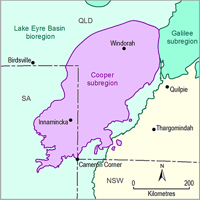
The Cooper subregion encompasses the surface footprint of the geological Cooper Basin. Most of the subregion is covered by undifferentiated Cenozoic sediments, with some Cretaceous rocks cropping out in the eastern and northern parts of the subregion. The geology of the subregion ranges in age from Cambrian to Holocene, although the main geological features are the Permian – Triassic Cooper Basin, the Mesozoic Eromanga Basin and the Cenozoic Lake Eyre Basin.
Sediment deposition in the Cooper Basin occurred from the Carboniferous to Early Triassic, and terminated due to widespread compressional deformation, regional uplift and erosion. It lies unconformably over early Paleozoic rocks of the Warburton Basin. Several major troughs are separated by structurally high ridges associated with the reactivation of north-west-directed thrust faults in the underlying Warburton Basin. These troughs contain up to 2500 m of sedimentary fill overlain by as much as 2850 m of Jurassic to Cenozoic cover. The Cooper Basin contains a number of stacked non-marine depositional sequences in the Late Carboniferous to Late Permian Gidgealpa Group and Late Permian to Early Triassic Nappamerri Group.
The Jurassic to Cretaceous Eromanga Basin unconformably overlies the Cooper Basin. Deposition within the Eromanga Basin was relatively continuous and widespread and was controlled by subsidence rates and plate tectonic events on the margins of the Australian Plate. Sedimentary rocks within the Eromanga Basin are divided into lower non-marine, middle marine and upper non-marine packages. The Early Cretaceous marine succession is dominated by thick transgressive shales, with thin sandstone units reflecting regressive cycles. In the Late Cretaceous upper non-marine succession, meandering fluvial systems crossed a floodbasin dominated by coal swamps and lakes.
The Cenozoic Lake Eyre Basin contains terrestrial sediments deposited following an extended period of erosion and deep weathering across the subregion. Significant periods of weathering, indicated by extensive silcrete and ferricrete formation, are recorded within the sediments of the Lake Eyre Basin.
Development of extensive aeolian dunes, fluvial systems, saline lakes, gibber plains and gypsum and carbonate paleosols occurred during the Pliocene–Quaternary. These surficial sediments reach a maximum thickness of 60 m in the Cooper subregion.
The Cooper subregion hosts Australia’s premier onshore hydrocarbon producing area. Oil and gas are produced from the rocks of the Cooper Basin, with some also produced from the Eromanga Basin. Unconventional hydrocarbon prospectivity in the Cooper Basin is high, with shale gas and deep coal seam gas currently under active exploration and appraisal. The coal within the Cooper and Eromanga basins is too deep for current mining methods (occurring at depths greater than 1 km), but is prospective for coal seam gas in parts.

