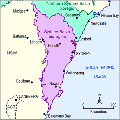
As described in Section 1.1. 1.1, the Sydney Basin bioregion aligns closely, but not exactly, with the Sydney Basin bioregion of the Interim Biogeographic Regionalisation for Australia (IBRA) classification (SEWPaC, 2012) – it also includes parts of the NSW South Western Slopes and South Eastern Highlands IBRA bioregions. The main IBRA subregions that occur within the Sydney Basin bioregion (as defined for use in the Sydney Basin Bioregional Assessment) are Wollemi, Yengo, Cumberland, Burragorang, Ettrema, Sydney Cataract, Jervis, Pittwater, Illawarra and Moss Vale; these account for nearly 92% of the bioregion. The Capertee Valley and Capertee Uplands IBRA subregions account for a further 7.1% of the bioregion. The vegetation characteristics of key IBRA subregions are described in detail in Table 21 (see also Figure 6 in Section 1.1.1 .1) based on Morgan (2001); details of geology, landforms and soils can be found in Table 7 in Section 1.1.2.1 .1.
The Sydney Basin bioregion is one of the most species diverse in Australia largely as a result of the variety of rock types, topography and climates in the bioregion. It includes lagoons, estuaries and coastal lake systems. It contains large areas of World Heritage and wilderness-listed national parks and includes a variety of vegetation types such as rainforest, wet and dry sclerophyll forest, and hanging swamps.
Table 21 Characteristic vegetation of the main Interim Biogeographic Regionalisation for Australia subregions in the Sydney Basin bioregion
aInterim Biogeographic Regionalisation for Australia (IBRA; Environment Australia, 2000)

