Summary
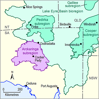
The Arckaringa Basin is a roughly horseshoe-shaped sedimentary basin containing predominantly Late Carboniferous and Early Permian sedimentary rocks. The basin is composed of a series of deep troughs that partially ring basement unit rocks that occur close to the surface. The surface geology of the Arckaringa subregion is largely composed of sedimentary rocks associated with the Eromanga Basin with occurrences of the Bulldog Shale typical. Wind-blown sediments associated with the current–day desert landforms are also common, although sediments associated with rivers, lakes and springs are restricted in extent.
There are three main geological formations within the Arckaringa Basin: the Boorthanna, Stuart Range and Mount Toondina formations. The Boorthanna Formation is the oldest of the three and consists of an upper unit composed of marine sediments grading from silt to boulders and a lower unit contains glacial sediments that vary from sandy to bouldery claystone to gravel. The Stuart Range Formation consists of mudstone, siltstone, and organic-rich shale. The Mount Toondina Formation is the youngest of the three and is composed of an upper sequence of grey carbonaceous shale and coal with interbeds of sandstone and siltstone and a lower sequence of marine shale and mudstone. Very little outcrop of Arckaringa Basin strata occur.
Directly overlying most of the Arckaringa Basin is the Eromanga Basin, which is synonymous with the Great Artesian Basin (GAB) in SA. In the Arckaringa subregion, the primary aquifer units are the Cadna-owie Formation and Algebuckina Sandstone with primary confining layers including the Bulldog Shale, Oodnadatta Formation and lateral equivalents within the Rolling Downs Group. Overlying the Eromanga Basin are the most recent phases of sedimentation primarily deposited in episodic river and lake environments. Underlying the Arckaringa Basin are rocks of the Warburton and Officer Basins and crystalline basement sequences. The potential for inter-basin connectivity between the Arckaringa Basin and the overlying Great Artesian Basin is thought to be largely influenced by the occurrence of confining layers, the development of former river valleys and the extent of faulting.
The shape and structure of the Arckaringa Basin was formed over a series of major tectonic events that have taken place since the Proterozoic. Additionally, valleys formed by glaciers prior to the deposition of Arckaringa Basin strata may have also influenced basin architecture. Deposition in the Arckaringa Basin appears to have ceased during the Early Permian. The Arckaringa Basin contains thick, extensive Permian coal measures comprising a number of discrete deposits within the upper Mount Toondina Formation. There are currently seven defined coal deposits of potential economic significance. In addition, the Arckaringa subregion is subject to conventional hydrocarbon and shale oil and gas exploration.

Product Finalisation date
- 1.1.1 Bioregion
- 1.1.2 Geography
- 1.1.3 Geology
- 1.1.4 Hydrogeology and groundwater quality
- 1.1.5 Surface water hydrology and surface water quality
- 1.1.6 Surface water – groundwater interactions
- 1.1.7 Ecology
- Citation
- Acknowledgements
- Contributors from the Government of South Australia
- Contributors to the Technical Programme
- About this technical product
