In the Namoi subregion the modelling domain consists of the catchment of the Namoi River above Walgett (Figure 4) which covers an area of about 38,500 km2. Almost one-third of the modelling domain is outside the subregion, mostly to the east of the Hunter-Mooki Thrust Fault System and including the Peel and Manilla river basins. Conversely, some parts of the western extremities of the subregion are outside the modelling domain because they are not part of the Namoi river basin.
Both the baseline and coal resource development pathway (CRDP) include simulations from 2013 to 2102. However, for both, the period from 1983 to 2012 is also modelled and acts as an extended model spin-up period.
Both surface water models, the Australian Water Resources Assessment (AWRA) landscape model (AWRA-L) and the AWRA river model (AWRA-R), operate on a daily time step. AWRA-L uses a spatial grid resolution of 0.05 x 0.05 degrees (approximately 5 x 5 km), while the smallest spatial unit in AWRA-R is the subcatchment, with size dictated by the location of model nodes. Unless indicated otherwise in this section, surface water modelling in the Namoi subregion follows the methodology set out in companion submethodology M06 (as listed in Table 1) for surface water modelling (Viney, 2016).
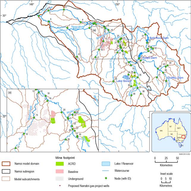
Figure 4 Location of surface water model nodes in the Namoi subregion and modelling domain
The extent of the coal resource developments in the coal resource development pathway (CRDP) is the union of the extents in the baseline and in the additional coal resource development (ACRD).
Data: Bureau of Meteorology (Dataset 1); Bioregional Assessment Programme (Dataset 2, Dataset 3)
