Summary
This product is limited to current publicly available water accounts and water quality information known to be available. This is due to the limited scope of work for the Cooper subregion part of the Lake Eyre Basin Bioregional Assessment Technical Programme (numerical modelling is not being undertaken), and the coal resource development opportunities (see companion product 1.2 for the Cooper subregion (Smith et al., 2015)). Additional information may be held by organisations or companies which is not publicly available.
Water accounts and water quality information is very scant for this bioregion and it may be very difficult to detect changes in either due to coal resource development with the current level of monitoring. For this reason, it would be difficult to assess impacts on water related assets as a result of any coal seam gas (CSG) development (no coal mining is identified in the coal resource development pathway).
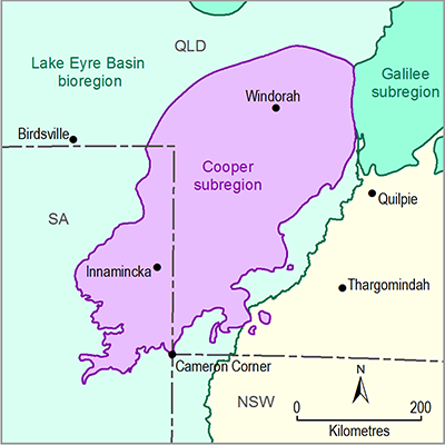
This product summarises surface water accounts for the Cooper subregion. The Cooper subregion incorporates a portion of Cooper creek basin and receives water from the two main tributaries of the Cooper Creek: the Thomson and Barcoo rivers. The surface water system in the Cooper subregion is unregulated and has not yet been affected by diversion or major dams. Surface water monitoring stations are relatively dispersed in the Cooper subregion and the mean flow varies between 3150 GL/year at Currareva and about 1430 GL/year at Innamincka. Currently, there are 40 general licences amounting to 17.1 GL and 24 stock and domestic licences amounting to 0.3 GL in the Queensland portion of the Cooper creek basin. There are no surface water licences for the South Australian part of the Cooper creek basin.
This product also summarises groundwater licensing and management for the Cooper subregion. Information presented here represents a compilation of SA and Queensland water licences. These data provide an overview of the water allocations in the subregion. Detailed water accounts are outside the scope of this report. Bores in the Cooper subregion access groundwater for stock and domestic purposes, exploration and industrial purposes (mostly petroleum industry), monitoring, and irrigation. Groundwater is managed according to state management plans. In SA, groundwater extraction from the Great Artesian Basin (GAB) is estimated at around 33.5 ML/day for stock and domestic use, 4 ML/day for town water supply with allowance for up to 60 ML/day for co-produced water from oil and gas extraction. This relates to the entire Far North Prescribed Wells Area (PWA) and, as such, a smaller portion of this groundwater is extracted from the Cooper subregion. Within the Far North PWA, there are 75 licensed groundwater extraction bores, with an approved take of approximately 50 GL/year (based on 2014 groundwater licence information).
There is a total of 168 existing groundwater licences (for 782 bores) within the Central and Warrego West groundwater management areas (GMAs) of the GAB water resource plan in the Queensland portion of the subregion. Of these, groundwater allocations are identified for 13 licences, with an entitlement totalling 3785 ML/year.

