Summary
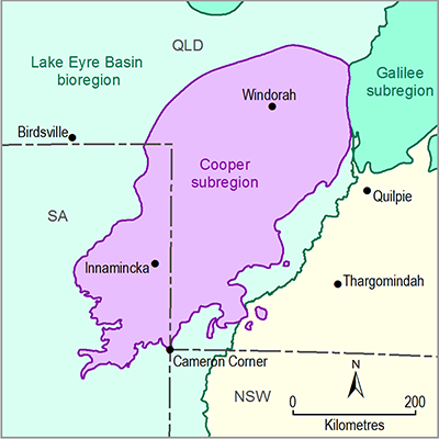
The Cooper subregion (130,000 km2) is within the Lake Eyre Basin bioregion. The Cooper preliminary assessment extent (PAE) occurs in south-west Queensland and north-east SA. Key features of the Cooper PAE are its large area, sparse human population density and unpredictable rainfall resulting in natural and human systems driven by resource pulses and boom-bust dynamics. The low human population results in the natural vegetation being relatively intact. A landscape classification was developed to present a conceptualisation of the main biophysical and human systems at the surface of the Cooper PAE and to describe their hydrological connectivity.
The approach taken was developed in close collaboration and with strong guidance from experts that have extensive experience with the landscapes of the PAE both in Queensland and SA, and who have contributed to the development of similar classification systems. The classification and typology were developed and refined following a six-step approach. The classification is based on five elements derived from the Australian National Aquatic Ecosystem (ANAE) Classification Framework: topography, landform, water source, water type and water availability. In addition, each area was identified as either remnant or non-remnant vegetation. This classification produced a typology consisting of 19 landscape classes that were then collapsed into eight broad landscape groups that were either non-water dependent, floodplain/lowland riverine, or non-floodplain (including upland riverine). The ‘Dryland’ landscape group dominated the area of the PAE (75.36%). Of the water-dependent landscape classes, 13.10% of the area of the PAE consists of floodplain landscape classes and 11.54% consists of non-floodplain landscape classes. The dominant landscape class on floodplains is ‘Wetland GDE, remnant vegetation’ (8.57% by area of the PAE). In contrast, a terrestrial GDE landscape class, ‘Non-floodplain terrestrial GDE, remnant vegetation’ (6.18% by area of the PAE) dominated the non-floodplain environment. The dominant stream landscape class is ‘Temporary, lowland stream’, which consists of 94.59% of the total stream network.
Each landscape group is described and representative areas of the PAE are mapped in this product. Aspects of water dependency within each landscape group are documented.

