The Methodology for bioregional assessments of the impacts of coal seam gas and coal mining development on water resources (the bioregional assessment (BA) methodology) (Barrett et al., 2013) states:
The central purpose of BAs is to analyse the impacts and risks associated with changes to water-dependent assets that arise in response to current and future pathways of CSG and coal mining development.
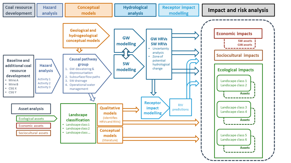
The impact and risk analysis for the Namoi subregion (Component 3 and Component 4) follows the overarching logic described in companion submethodology M10 (as listed in Table 1) for analysing impacts and risks (Henderson et al., 2018), and is summarised diagrammatically in Figure 4. It builds on the contextual information (Component 1) and knowledge developed through identification of conceptual models of causal pathways, numerical groundwater modelling and data analysis (Component 2) (as listed in Table 2).
The impact analysis quantifies the magnitude or extent of the potential hydrological or ecosystem changes due to coal resource development. This includes considering:
- direct impacts: a change in water resources and water-dependent assets resulting from coal seam gas (CSG) and coal mining developments without intervening agents or pathways
- indirect impacts: a change in water resources and water-dependent assets resulting from CSG and coal mining developments with one or more intervening agents or pathways
- cumulative impacts: the total change in water resources and water-dependent assets resulting from CSG and coal mining developments when all past, present and reasonably foreseeable actions that are likely to impact on water resources are considered.
The risk analysis is related, however, it considers not only the magnitude or extent of the potential impact, but also the likelihood of that impact eventuating. This is often framed as ‘consequence multiplied by the likelihood’. A dedicated uncertainty analysis underpins the quantification of the likelihood and allows probabilistic statements about certain events or impacts occurring. Within BAs, the uncertainty analysis stochastically propagates uncertainties in underlying hydrological parameters through hydrological models to produce distributions of potential surface water and groundwater changes. These in turn are inputs into receptor impact models to produce distributions of receptor impact variables, which serve as indicators of potential ecosystem impacts.
BAs identify risks through a hazard analysis and analyse those risks by estimating the magnitude and likelihood of specific impacts. The risk assessment, risk evaluation and the risk treatment that occur as part of the broader risk management (see, for instance, ISO 31000:2009 Risk management – principles and guidelines (ISO, 2009)) are beyond the scope of BAs because they require careful consideration of a number of non‐scientific matters and value judgements; these are roles of proponents and government regulators in the first instance, often in response to specific community values.
This product describes the predicted hydrological changes, and then the potential impacts of those changes on landscape classes and water-dependent assets, which contain ecological, economic and sociocultural values. These regional-scale results do not replace the need for detailed site or project specific studies, nor should they be used to pre-empt the results of detailed studies that may be required under NSW legislation. Where the regional analysis identifies potential impacts, local-scale information can improve the risk evaluation.
BAs present the likelihood of certain impacts occurring, for example, the percent chance of exceeding 0.2 m of drawdown in a particular aquifer and location (see Section 3.2.3). The information that is generated and that underpins statements like this is available for others to access at www.bioregionalassessments.gov.au and use in their own targeted risk assessments. Users can choose thresholds of impact that may threaten the specific values they are trying to protect and calculate the corresponding likelihood of occurrence. More details about hydrological changes and potential impacts in the Namoi subregion are available at www.bioregionalassessments.gov.au/explorer/NAM.
Figure 4 Overarching methodology for impact and risk analysis in bioregional assessments
CSG = coal seam gas, GW = groundwater, HRV = hydrological response variable, RIV = receptor impact variable, SW = surface water

Product Finalisation date
- 3.1 Overview
- 3.2 Methods
- 3.3 Potential hydrological changes
- 3.4 Impacts on and risks to landscape classes
- 3.4.1 Overview
- 3.4.2 Landscape classes that are unlikely to be impacted
- 3.4.3 'Floodplain or lowland riverine' (non-Pilliga) landscape group
- 3.4.4 'Non-floodplain or upland riverine' (non-Pilliga) landscape group
- 3.4.5 Pilliga riverine (upland and lowland)
- 3.4.6 Potentially impacted landscape classes lacking quantitative ecological modelling
- References
- Datasets
- 3.5 Impacts on and risks to water-dependent assets
- 3.6 Commentary for coal resource developments that are not modelled
- 3.7 Conclusion
- Citation
- Acknowledgements
- Contributors to the Technical Programme
- About this technical product

