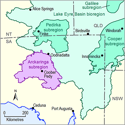
1.3.2.1.1 Introduction to assets by subgroup, class and data source
The total number of ecological water-dependent assets in the PAE of the Arckaringa subregion is 1845 (from a total of 2239 ecological assets in the asset list). Of the water-dependent assets, 1027 assets are vegetation features, 730 assets are surface water features and 88 assets are groundwater features (Table 7). Most of the vegetation features are groundwater-dependent ecosystems (GDEs) and most of the surface water features are wetlands, wetland complexes or swamps. Of the ecological assets, 1719 assets were assessed as dependent on surface water and 1448 assets were assessed as dependent on groundwater. Of these assets, 396 assets were assessed as dependent or possibly dependent on surface water alone, 122 assets were assessed as dependent or possibly dependent on groundwater alone, and 1327 assets were assessed as dependent or possibly dependent on both surface water and groundwater.
Table 8 summarises the ecological assets and their water dependence according to database source. Maps of the distributions of the key data sources are shown in Figure 12 to Figure 17. Total assets cover a large proportion of the 82,505 km2 area of the Arckaringa PAE, giving confidence that the asset register is a thorough basis for the assessment of potential impacts of coal resource developments during later stages of the BA. In some datasets, at least some large assets intersect with only a small part of the Arckaringa PAE and extend far beyond the boundaries of the PAE. This is most strongly the case for the Water Asset Information Tool (WAIT) database, in which Great Artesian Basin (GAB) groundwater aquifers, recharge beds and dependent ecosystems extend to the west, south and east far beyond the boundary of the Arckaringa PAE.
Table 7 Summary of ecological assets within the preliminary assessment extent (PAE) of the Arckaringa subregion, according to asset subgroup and class
Data: Bioregional Assessment Programme (Dataset 1)
Table 8 Summary of ecological assets in the preliminary assessment extent (PAE) of the Arckaringa subregion, according to asset data source
Data: Bioregional Assessment Programme (Dataset 1)
Data: Bioregional Assessment Programme (Dataset 1)
Data: Bioregional Assessment Programme (Dataset 1)
Data: Bioregional Assessment Programme (Dataset 1)
Data: Bioregional Assessment Programme (Dataset 1)
These are polygons representative of the combined area of assets. Data: Bioregional Assessment Programme (Dataset 1)
Data: Bioregional Assessment Programme (Dataset 1)
1.3.2.1.2 Threatened ecological communities
Only one ecological community listed under the EPBC Act occurs in the Arckaringa PAE. Management plans indicate that ‘The community of native species dependent on natural discharge of groundwater from the Great Artesian Basin threatened ecological community’ depends eponymously on groundwater. Assessment data based on all satellite imagery data layers provides independent corroboration that this ecological community is water dependent. Most of these discharge springs occur to the west and south of Kati Thanda – Lake Eyre, with the Dalhousie Springs group lying further north, between Oodnadatta and the NT–SA border (Figure 16).
1.3.2.1.3 Habitats of threatened species
Of the 19 species listed as threatened under the EPBC Act and occurring in the Ackaringa PAE, 9 species were assessed to rely upon water-dependent habitats, with 6 species dependent on surface water, 1 species dependent on groundwater and 2 species dependent on both surface water and groundwater (Table 9). Application of the precautionary principle means that any species that is ‘possibly’ dependent on water in excess of incident rainfall is determined to be water dependent and its habitat is included in the register of water-dependent assets. One of the three EPBC Act-listed species that are at least partly dependent on groundwater (Eriocaulon carsonii) is exclusively associated with ‘The community of native species dependent on natural discharge of groundwater from the Great Artesian Basin threatened ecological community’. For the other two species (both egrets), evidence for dependence on groundwater or surface water is much less clear cut. The species occur across a wide range of community types that are more commonly ephemeral rivers, creeks, swamps and floodplains than permanent waterbodies. Groundwater may contribute to the water supply in some of these community types, through contributions to subsurface baseflow in rivers and creeks, or to soil water in swamps and floodplains. In all these community types, determination of absolute dependence on water in excess of rainfall (i.e. flows down drainage lines and across floodplains) cannot be made with complete confidence, and in all cases the precautionary principle has been applied to assess these species’ habitats.
Table 9 Water-dependent threatened species listed under the Commonwealth’s Environment Protection and Biodiversity Conservation Act 1999 and within the preliminary assessment extent (PAE) of the Arckaringa subregion
Although examples of individual species are listed, bioregional assessments consider the potential impact to the habitat of species not individual species per se.
Data: Bioregional Assessment Programme (Dataset 1)
aTypology and punctuation are given as they are used in the legislation.


