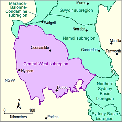
The Central West subregion, of the Northern Inland Catchments bioregion, is located within the Murray–Darling Basin (MDB) in central NSW. It spans an area of 46,735 km2, extending from the plains around Dubbo across the low-lying alluvial plains of the Macquarie and Castlereagh river systems north-west to the Barwon River floodplains. Maximum and minimum elevations for the subregion itself are 1235 and 95 mAHD in the Warrumbungle Ranges and near Brewarrina, respectively.
The main rivers draining the subregion are the Macquarie, Castlereagh and Bogan rivers. The headwaters of the Macquarie River, including the Cudgegong river basin and the Burrendong, Ben Chifley and Windamere dams that regulate river flows in the Macquarie river basin, lie outside the subregion. The southern part of the Bogan river basin is also outside the subregion. The subregion’s most significant water-dependent asset is the Macquarie Marshes, located toward the lower end of the river basin. There are very few wetlands in the Castlereagh river basin, but woodlands and shallow wetland complexes occur on some of the effluents in the lower river basin.
The dominant soils on the Upper Darling Plains and Cobar Plains are grey and brown Vertosols and red Chromosols. The Vertosols are well-structured and have a good mix of pores for both transmitting and storing water, so plant growth on these soils is typically very good relative to other soil types and they are agriculturally very valuable. The main land and soil hazards in the subregion are soil salinity and waterlogging, structural decline, carbon decline, acidification and wind erosion. The majority of land is being used ‘at capability’, meaning the risk of degradation under current land use and management is low (NSW DECCW, 2010a). However soil acidification is widespread in the Dubbo-Coonabarabran area (NSW OEH, 2013a).
The subregion has undergone significant modification of its land cover, with an estimated 62% of the land cleared of native vegetation. Much of the remnant vegetation occurs as a large number of small, isolated patches on the less fertile and productive soils and a smaller number of scattered larger reserved remnants. The 2010 State of the Catchment report for the Macquarie, Castlereagh and Bogan river basins (NSW DECCW, 2010c) rated the vegetation condition as fair and the pressures on land cover as moderate. The main pressures on vegetation extent and condition come from dryland agriculture. Intensive uses and irrigated agriculture and plantations have small, localised impacts around Dubbo and along the Macquarie River between Dubbo and the Macquarie Marshes. NSW recognises eight endangered ecological communities in the Central West subregion, five of which are listed as endangered and one as critically endangered under the Commonwealth’s Environment Protection and Biodiversity Conservation Act 1999.
The subregion has a mean annual rainfall of 520 mm (1900 to 2011) and is characterised by hot summers and mild winters.
Dubbo is the major population centre for the subregion with a population of about 40,000. Coonabarabran, Coonamble, Gilgandra and Nyngan are smaller population centres within the subregion. Approximately 30% of the employed community outside of Dubbo works in the agriculture sector (ABS, 2011). The gross value of agricultural production in the Central West region in 2010 to 2011 was estimated at $1.37 billion. Regional tourism is also significant and the reported $1.13 billion in 2011 is from a much larger area than the subregion; perhaps a quarter to one-third of this could be attributed to the subregion.

