- Home
- Assessments
- Bioregional Assessment Program
- Central West subregion
- 1.1 Context statement for the Central West subregion
Executive summary

The context statement brings together what was known about the geography, geology, hydrology and ecology of the Central West subregion as at August 2014.
Geography
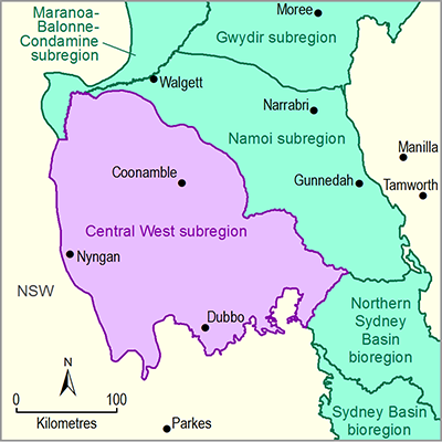
The Central West subregion is located in the Murray–Darling Basin in central New South Wales and spans an area of approximately 46,735 square kilometres. It extends from the plains around Dubbo across the low-lying alluvial plains of the Macquarie and Castlereagh river systems, north-west to the Barwon River floodplains.
The major centre in the subregion is Dubbo, with a population of 40,000 people. Smaller centres in the subregion include Coonabarabran, Coonamble, Gilgandra and Nyngan.
About 85% of land in the subregion is used for agricultural production – primarily cropping and grazing.
Geology
The Central West subregion has three distinct coal-bearing geological basins: the Surat, Gunnedah and Sydney basins. The Gunnedah and Sydney basins are bounded by the New England Fold Belt and the Hunter-Mooki Thrust, the latter having formed when the western edge of the New England block moved over the eastern edge of the Gunnedah Basin. The Sydney Basin is bounded in the east by the offshore continental margin.
The Central West subregion’s geological basins consist mostly of sandstone, siltstone, claystone, coal and volcanic deposits. The Sydney Basin has the thickest formation of sedimentary rock reaching a depth of 5.9 kilometres in the north.
Surface water and groundwater
The main rivers draining the subregion are the Macquarie, Castlereagh and Bogan rivers. The three major public water storages in the Macquarie river basin, namely Burrendong, Windamere and Chifley dams, are all upstream of the subregion. The Macquarie Marshes are the main wetlands in the subregion. Weirs and off-river storages in the Macquarie river basin account for an additional 943 gigalitres of water storage. The Castlereagh River has no major public water storage dams.
The Central West subregion overlies the Great Artesian Basin. Groundwater is mainly sourced from the upper alluvial aquifers and is used mostly in the Lower Macquarie System.
The subregion has a mean annual rainfall of 520 mm (based on records from 1900 to 2011).
Ecology
Large tracts of important wetland and floodplain communities occur in the western portions of the subregion, including the internationally recognised Macquarie Marshes. These marshes contain large tracts of red gum woodlands and nationally significant coolibah-black box woodlands, nesting sites for over 40 species of waterbirds, and breeding habitat for endangered and threatened aquatic species.
The subregion contains 65 aquatic and terrestrial threatened species listed under Commonwealth legislation and over 140 species listed as threatened under state legislation.
New South Wales recognises eight endangered ecological communities in the subregion, five of which are listed as endangered and one as critically endangered under Commonwealth legislation.

