The contextual information component provides a series of information products that characterise the bioregion, and are used to support qualitative or quantitative assessments of impact and risk.
3.1 Bioregional context
3.1.1 Definition of bioregion as used in bioregional assessments
The concept of a bioregion (a biologically distinct or defined region) is well known and understood across a range of disciplines, including ecology, biogeography and conservation management. Consequently, a number of bioregional concepts have already been defined in the literature and in practice, but none of these clearly encompasses the mixture of CSG and coal resources, assets, receptors and management units required in the BA methodology. To provide clarity, a bioregion in the context of the BA methodology is defined in this section. The principles of 'materiality of impacts' and 'receptors' are critical to the delineation of the spatial extent of a bioregion. In general, receptors are sensitive to changes in flow and/or water quality and so the spatial extent of a bioregion should be sufficient that it covers all receptors contained within water-dependent assets that are materially affected (or likely to be) by CSG and coal mining development. After all of these considerations, the ultimate decision as to the spatial extent of a bioregion is arbitrary and lies with the government, with advice from the IESC. The bioregion may be subdivided for convenience into a series of sub-regions to facilitate presentation of outputs and analyses. Sub-regions are wholly contained within bioregions and to a large degree are independent of other sub-regions.
In an Australian natural resource management context, the most common understanding of the term 'bioregion' is that used in the Interim Biogeographic Regionalisation for Australia (IBRA; SEWPaC, 2012). The IBRA bioregions are derived from the work of those state and territory agencies that map vegetation communities and land systems. The bioregions and sub-regions within them are the reporting units for assessing the status of native ecosystems and their protection in the National Reserve System. Much of the data collected at the IBRA scale will be relevant to the BA methodology. However, IBRA regions and sub-regions (derived from topographical and climatic factors which influence vegetation composition and structure) are poorly correlated with the distribution of CSG and coal resources, or with groundwater or surface water catchments.
Other examples of bioregional definitions recognised in an Australian legislative context include those employed under the Ramsar Convention, and the Convention on Biological Diversity. The Ramsar Convention (2006) recognises a biogeographic region as being a 'scientifically rigorous determination of regions as established using biological and physical parameters such as climate, soil type, vegetation cover, etc.' and goes on to note that 'in some circumstances, the nature of biogeographic regionalisation may differ ... according to the nature of the parameters determining natural variation'. Bioregions recognised by Ramsar (for example, the Riverland, South Australia) tend to recognise component parts of terrestrial catchments and so sit within bioregions recognised by this report and as such may provide valuable contextual data and information both on assets and potential means of exposure of those assets to changes in environmental water quality or quantity due to CSG or coal mining development.
The definition of a bioregion adopted in the BA methodology is compatible with 'a geographical space that contains one whole or several nested ecosystems' (Miller, 1996). A bioregion encompasses a discrete set of assets and receptors and is defined on the basis of CSG or coal mining development, impacts or management boundaries, whichever proves the most appropriate (see Section 2.2). The bioregion takes into account the vertical and horizontal distribution of surface and subsurface features associated with surface water and groundwater hydrology and the CSG and coal resources (see Table 1). This definition builds on the existing recognition that the definition of a particular bioregion depends on the scale at which its characteristic features are measured (DEH, 2006).
Table 1. Vertical and horizontal distribution of features that influence the spatial extent of a bioregion considered in a bioregional assessment
|
Features |
Determining factors |
|
|---|---|---|
|
Surface |
Landform, vegetation, community, surface water hydrology, catchments, groundwater recharge and discharge zones |
Soils, climate, land use, geomorphology |
|
Subsurface |
Groundwater systems, alluvium |
Geology, geomorphology, climate |
|
Subsurface |
CSG and coal mining development |
Geology |
Figure 3 illustrates these concepts with a stylised representation of a bioregion as defined in the BA methodology. The bioregion takes into account the vertical and horizontal distribution of surface and subsurface features associated with surface water and groundwater hydrology and the CSG and coal resource where it intersects or has direct, indirect or cumulative impacts with surface assets (quantified through the impacts on receptors). The identified assets in this hypothetical bioregion are irrigated cropping, a gaining or losing river, and a groundwater-dependent ecosystem (GDE). The receptors within these assets are water levels in wells tapping shallow and deep aquifers for use in irrigated cropping; flow at nodes along the river system; and specific aspects of the GDE such as abundance of nesting sites or communities dependent on seasonal inundation for part of their life cycle. The bioregion contains four ecosystems with the GDE embedded within ecosystem 3, an alluvial aquifer adjacent to a shallow aquifer that are both actively recharged, two deeper aquifers used to supplement irrigation water during dry periods, two coal measures from different geologic basins (one overlying the other), and all underlain by a deep aquifer. The horizontal scale is of the order of 100 km and the vertical scale is approximately 0.5 km. In this hypothetical example, the shallow coal measure is depressurised using vertical drilling for CSG extraction while the deeper coal measure is horizontally drilled. An open-cut and underground coal mine exists where coal seams occur within 150 m and 200 m of the surface, respectively, and dewatering of the associated aquifers is required for coal extraction.
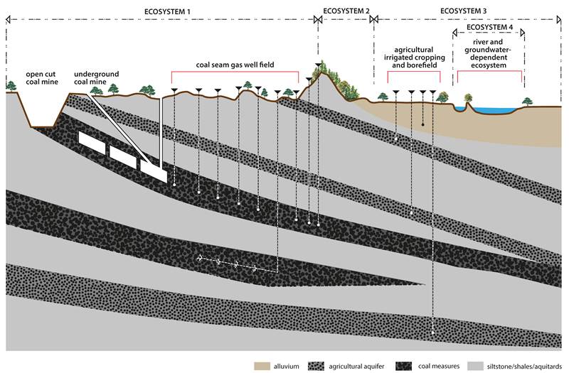
Figure 3. Stylised depiction of relationships between coal resources, mining, coal seam gas extraction, water resources and uses, and ecosystems within a hypothetical bioregion
3.1.2 Relevant spatial scales for different assets
Data available to support the BA methodology (identified and acquired in Component 1) will have been generated for various purposes by a variety of individuals, organisations and agencies. It is also likely to have been generated at a variety of spatial scales, some of which will have more relevance to the BA methodology than others.
Data and model resolutions of 1 km2 may be sufficient for some broad applications (e.g. the Rapid Regional Prioritisation Process; IIESC, 2012). This was adequate to assess the likelihood of broad asset classes intersecting with CSG and coal mining development, but in considering exposure of assets and receptors, other spatial scales may be more appropriate to fully realise the potential for impacts and their amelioration. For example, vegetation is typically mapped at the 1:50,000 or 1:100,000 scale, and for management, conservation and statutory protection under the EPBC Act vegetation units of 1 ha may be considered, so for listed communities such a resolution is preferable for consideration rather than the 1 km2 scale.
When dealing with protected species, the spatial scale considered should be determined with reference to their biology, and to the life history stages potentially affected through changes in water quality or quantity. This may mean that for some assets any potential exposure needs to be considered at a supra-regional scale, while for other assets point-source impacts may be more appropriate.
3.2 Context statement
The context statement assembles, organises and reports pre-existing data sets and information on the ecological, hydrological, geological and hydrogeological characteristics of a bioregion and its sub-regions, as well as its anthropogenic and ecological receptors . A key component of the contextual statement is a scientific review of all relevant literature and evidence on:
- the direct, indirect and cumulative impacts of CSG and coal mining development on human and natural systems
- the time and space scale of these impacts
- key receptors and response variables to be considered in a BA.
The information is relevant as a descriptive baseline.
3.2.1 Geology
The geology of bioregions provides the fundamental information for understanding CSG, coal and groundwater resources. An understanding of the geology allows the determination of the spatial distribution of future mining activities and their potential impacts. The geological characterisation of a bioregion requires analysis of all available information including the (i) geological structural framework, (ii) stratigraphy and rock types, and (iii) basin history.
3.2.1.1 Geological structural framework
The size and form of the major sedimentary basins and their controlling basement structures provide an important basis for understanding bioregions and their interaction with extractive industries. The location of major coal-bearing basins within the bioregions will define the spatial distribution of potential locations for coal mining and CSG extraction. Detailed structural mapping of the basin needs to be undertaken and key stratigraphic units (aquifers, aquitards, coals) identified. Basin boundaries need to be mapped and groundwater movement through the basin understood.
The depth of coal-bearing units from the surface is the primary controlling factor in the identification of bioregions where coal mining is possible and CSG extraction likely. Presently, coal mining is restricted to areas where coal can be found at depths of less than 600 m. Therefore only bioregions where coal occurs at less than this depth are likely to be mined by open pit and underground techniques.
Depth of the objective coal sequences is also a significant control on CSG development. CSG developments in Australia have traditionally targeted coal sequences between 200 m and 1000 m below the land surface (Draper and Boreham, 2006). The depth cut-off for CSG developments reflects decreasing permeability with depth and the high cost of drilling the many deep wells required to achieve viable CSG production. While technological advances may improve the efficiency of deep CSG drilling, the depth of the objective coal beds will remain a critical limiting factor on the location of CSG developments.
Structural framework studies should also include mapping of major faults, folds and other tectonic features. Faults form discontinuities that may allow enhanced vertical fluid migration between units and between aquifers and the surface. Conversely, faults and folds may isolate parts of rock units from fluid flow. Faults, folds and joints are important in some CSG fields in enhancing coal permeability (Draper and Boreham, 2006). To assist in the understanding of fault orientation and distribution within a basin and the potential behaviour of sedimentary rocks that may be subjected to hydraulic fracturing as part of a CSG development, analysis of tectonic stress regimes may be required.
3.2.1.2 Stratigraphy and rock type
The distribution and character of sedimentary units should be determined (facies analysis). At a basic level, the presence or absence of coal in part of a bioregion determines whether there will be any direct impacts, downstream effects or no impacts at all. Sedimentary units are rarely homogenous and frequently exhibit great vertical and lateral variability. Palaeogeographic and lithofacies analysis of coal-bearing sequences, aquifers and aquitards is therefore required. Overburden thickness, the volume of accessible coal and coal rank determine the distribution of coal mining activity within a basin. While the thickness of individual coal seams is a key determinant of coal mine viability, the total amount of coal present within a sedimentary unit(s) is a key determinant of CSG potential. Understanding groundwater resources, groundwater flow, CSG potential and the risks associated with CSG extraction requires a detailed knowledge of the structural geology of the basin and an understanding of the sedimentary units found within the stratigraphic succession.
An integrated approach to stratigraphic analysis that includes quantitative well log analysis, core and cuttings analysis, petrophysical measurements (porosity, permeability) and geophysical interpretation should be used to quantify the properties and the distribution of the key sedimentary units (coal, sandstone, shale, mudrocks) within the basin, with particular reference to their ability to allow or impede the flow of groundwater. This will improve the understanding of the basin architecture and heterogeneity within aquifers and aquitards. Where geophysical and well data are either sparse or absent, the applicability of methodologies such as geostatistics should be investigated.
3.2.1.3 Basin history
Basin history – with particular reference to coal-bearing units, aquifers and aquitards – needs to be obtained from pre-existing modelling and exploration data. The thermal history of a basin must be documented as this determines coal rank, the composition (including CO2 content) and volume of gas associated with coal and coal permeability. These are key factors in determining the potential of a coal to constitute either a mineable deposit and/or a source of CSG. Basin history must include an understanding of the evolution of groundwater systems. This approach will enable factors in a basin's evolution to be identified that may have an impact on potential viability of CSG and coal resource development pathways.
3.2.2 Hydrogeology and groundwater quality
Existing information on the hydrogeology of a bioregion must be obtained and documented so that the potential impacts of coal mining and CSG extraction (such as saline water and fraccing chemicals) may be evaluated. Pre-existing information should include hydrostratigraphic characterisation of the bioregion from the surface to basement rocks. While the hydrostratigraphy will refer to the units discussed in Section 3.2.1, they will be identified in terms of their main hydrogeological characteristics (aquifer, aquitard, aquiclude). The assessment should include mapping of the lateral and vertical extents of individual hydrostratigraphic units, identifying recharge and discharge areas and zones of potential leakage between units.
Pre-existing information on hydraulic properties (such as hydraulic conductivity, porosity and interaction with other units) should be documented for each hydrostatigraphic unit. In cases where there are insufficient data to adequately characterise hydrostratigraphic units, this too must be identified at this stage. The degree to which the available data adequately characterises individual hydrostratigraphic units should also be assessed and documented. Prior evidentiary material used to describe the hydraulic and flow characteristics of these units should be clearly identified and referenced. Studies on the extent and integrity of hydrostratigraphic units must be discussed in the context of how they contribute to the understanding of their hydraulic characteristics and flow behaviour. A discussion of the lateral variability within individual hydrostratigraphic units should be included.
Where possible, estimates of baseline groundwater chemistry, including hydrocarbon concentration and composition, is required to allow reliable detection and attribution of any changes which may take place due to CSG activities. This information, when incorporated with hydrodynamic and geological models, will assist in detecting and estimating existing inter-aquifer connection. Further, the spatial variability of hydrochemistry in groundwater can contribute to the conceptualisation of existing groundwater flow regimes.
Hydrodynamic baseline information on physical groundwater conditions (level, pressure, temperature and flow direction) should be provided. In the absence of appropriate data, an appropriate data collection program should be undertaken as part of the BA to establish the baseline information against which the impact of future activities may be measured. Any baseline data collected should be viewed and reported in the context of historical trends (e.g. a single water level measurement may be misleading if long-term trends are not considered).
The assessment should include a discussion of the influence of structural and/or stratigraphic features (building upon features identified by the geological assessment in Section 3.2.1) on hydraulic properties and flow behaviour within and between hydrostratigraphic units.
The potential for interconnection between hydrostratigraphic units and between surface water bodies, including the support of groundwater-dependent ecosystems (GDEs), should be articulated. This information will provide the basis to clearly identify the extent of understanding of the groundwater system in the bioregion, both laterally and vertically.
3.2.3 Surface water hydrology and water quality
Surface drainage networks and associated hydrological features are available through the Australian Hydrological Geospatial Fabric (Geofabric) at www.bom.gov.au/water/geofabric. Hydrologic flow data and models are available from respective state water resource agencies and from the Murray–Darling Basin Authority for the Murray–Darling Basin. Ambient water quality data and contaminated water body information are available through state resource agencies and natural resource management authorities. Where information on water quality guidelines is required the Australian and New Zealand Guidelines for Freshwater and Marine Water Quality (ANZECC, 2000) should be consulted.
3.2.4 Geography
In addition to a range of assets, each bioregion will also support regional communities. The distribution and extent of human habitation in Australia has been influenced strongly by the quality and quantity of water, in particular inland freshwater resources. The size and distribution of the human population within a bioregion will be a significant factor in assessing the potential impact of CSG and coal mining development, because the size of the population base will not only determine human water use, but have a major influence on local land use patterns, including access to water bodies for recreational purposes. For these purposes, human water use is defined to include the use of water resources for household and industrial processes where industrial uses represent agriculture, urban, mining and other industry.
The population for each bioregion can best be calculated using census data, which are available as population density (number of people per square kilometre) for the whole of Australia. Population density estimates are available for 2005/06 from ABARES. Data on land use activity, which refers to the spatial distribution of permanent uses of land (including urban, industrial and agricultural uses), may be overlain with the population data to indicate potential exposure of human use systems to changes in the quality and quantity of inland waters. Catchment-scale land use maps of Australia as at May 2010 are available from ABARES. Each assessment should summarise water accounts (including current under-utilised entitlements) and domestic, agricultural, environmental and industrial uses, including mining.
3.2.5 Ecology
Water is available to organisms in a range of spatial and temporal patterns, and the combination of this availability and a species' abilities to use it generates a range of water-based dependencies. The significance of water, particularly in an arid continent such as Australia, has also resulted in a wide range of cultural and spiritual associations between people and water bodies or between water-dependent species and ecosystems.
In providing the environmental context for each BA, an attempt should be made to draw together the biotic components with the abiotic drivers for the bioregion, namely the climate, geology, soil, and groundwater factors, which together determine the nature, dynamics and resilience of the environment and ecosystems. These abiotic components also largely shape the agricultural utility of a landscape, though potentially supplemented through irrigation and fertiliser application.
The primary data layers should comprise vegetation, wetland, floodplain, species, river flow, and groundwater dependency spatial datasets that identify the distribution of organisms, communities and ecosystems comprising assets and receptors. It is necessary to acquire all available information on aquatic dependencies of vegetation and fauna and to sufficiently define the distribution of organisms and processes to link dewatering and depressurisation at depth with impacts on receptors at or near the surface. Secondary layers should include finer-resolution vegetation and land-cover maps, local-scale mapping and distribution of species, and single studies on single ecosystems or communities to develop an understanding of condition, extent, conservation and management status of assets and receptors. In addition to the landscape-scale understanding of the environment, detailed contextual information about receptors also needs to be compiled. Identification of species of international, national, regional and local conservation concern is required, which for motile species should consider significant locations for key activities such as nesting, spawning or feeding. For some taxa, the available distribution data will be of limited extent, particularly for lower plants and many invertebrate groups. A precautionary approach is suggested, with best available information extrapolated into unsurveyed regions; expert advice sought, as appropriate; or supplementary survey effort commissioned, as appropriate.
3.3 Coal seam gas and coal resource assessment
3.3.1 Available coal seam gas and coal resources
Methodologies and protocols for the assessment of coal resources are well established in Commonwealth and state government agencies, with spatial data available from existing databases (e.g. Geoscience Australia's OZMIN database). These data can be extracted and adapted to provide products and to support other aspects of the BAs as they progress.
CSG resource assessment is an emerging field where the methodologies used to estimate gas resources are evolving. The methodology used for conventional gas resource assessment is not applicable to CSG resource assessment. The situation is complicated by the observation by industry that 'every CSG field is different'. Regional CSG resource assessments have yet to be undertaken in Australia.
The identification of locations likely to contain viable CSG reserves will require the geological structural framework studies described in Section 3.2.1.1 and a consistent methodology to assess CSG resources in all bioregions and sub-regions. This methodology will need to be developed in close consultation with state and federal government groups responsible for petroleum resource assessment and industry to ensure it is rigorous and consistent with prevailing industry practice.
3.3.2 Existing mining activity and tenements
Coal mining activities and tenements are documented in state and federal databases. The assessment should use data on current mining operations and historical mines. Historical mines – and their impacts – can indicate potential issues with current and future developments. Data on existing activities and tenements are managed by state authorities. Engagement with industry will be required to ensure that the implications of various development options are canvassed.
3.3.3 Proposals and exploration
Existing coal resource assessments – combined with overburden mapping – will allow prediction of likely locations of future mining and the type of mining that will be undertaken (for example, open pit, longwall, or board and pillar). The potential impacts of different extractive approaches can then be assessed.
Coal resource development proposals across their development horizon must provide as much engineering information as possible in order to comprehensively address the sets of assumptions associated with the development pathway and be based on the proven and probable (2P) gas reserves. Modelling of basin geological development and strata reconstruction should be undertaken where possible. This should include (to the extent possible for mining):
- the engineering methods to extract coal (for example, caving, open pit, longwall underground)
- life of mine plan
- impacts of mining on land surface subsidence
- dewatering method, well layout and water treatment methods
- mine dump and tailings locations and hazards
- decommissioning methods, well capping and goaf closure
- pit lake management plans.
For CSG extraction, details should include:
- drilling methods (vertical and horizontal)
- hydraulic fracturing methods
- origin and management of water for hydraulic fracturing
- volume, quantity and destination expected for associated water and its treatment
- decommissioning plans of CSG facility (for example, sealing of wells).
3.4 Water-dependent asset register
A water-dependent asset is defined as:
an entity contained within a bioregion where the characteristics can be ascribed a defined value and which can be clearly linked, either directly or indirectly, to a dependency on groundwater or surface water quantity or quality.
Examples of water-dependent assets may include a particular wetland spring system and associated surface features, or a named species or ecological community.
The documentation of assets occurs in a water-dependent asset register prepared by external natural resource management and state agencies in consultation with stakeholders. The register includes those assets which are covered by Council of Australian Governments agreements (e.g. Paroo River, Lake Eyre Basin). Where state research initiatives and/or projects have identified water-dependent assets, including statutory water planning initiatives, these must be included directly in the asset register. Any available information on the nature of the value of these assets, including that on resilience, threat, vulnerability or susceptibility to change, should be listed in the register. For each water-dependent asset described in the register, a set of receptors are identified and listed in a separate receptor register. Consideration should also be given particularly to those assets or receptors that are sufficiently mobile that they intersect with a single bioregion for only part of their life history, and to those that have a short but significant interaction with a hydrological feature. Such assets or receptors may include organisms that rely on surface water availability during critical seasons for reproduction, or that are critically dependent on water bodies for food resources or shelter during brief times. Other such assets may be agricultural irrigation districts or regional cities located in portions of catchments that are outside of a bioregion. In such cases, the boundary of a bioregion should be extended to incorporate these assets if cumulative impacts are of concern.
Each BA is expected to have some variation in the water-dependent asset register reflecting differing environmental laws or protections, scientific understanding, and those identified values derived from regional communities.
Assets in the water-dependent asset register should include, but not be limited to, the following:
- landscape elements that have statutory protection over them, for example, sites on the World Heritage List or recognised under the Ramsar Convention; national and state parks and their equivalents; and areas designated under the Indigenous Protected Areas program (listings held by SEWPaC in CAPAD, MNES, WHA and Ramsar data)
- ecological communities that are protected under federal legislation, such as critically endangered communities as scheduled under the EPBC Act (data held by SEWPaC)
- species that are protected by international (e.g. IUCN red lists), federal (EPBC Act) or state and territory (e.g. Queensland's Nature Conservation Act 1992) legislation (listings in MNES data held by SEWPaC and important bird areas (IBAs) for migratory species as identified by Birds Australia)
- ecological systems such as riverine floodplains, rivers, streams (e.g. TRaCK program), groundwater-dependent ecosystems (e.g. Australian National GDE Atlas), springs, mound springs, karst formations, wetlands (including bog mosses), terminal lakes, estuaries, aquifers (hard rock, sedimentary, perched and alluvial), and groundwater stygofauna
- significant cultural sites, whether areas concerned are declared under Native Title legislation, or whether they have pending decisions on Native Title claim over them. Native Title does not confer legislative protection to areas per se, but many determinations allow Indigenous Australians who hold native title, or who have a pending native title claim, the right to be consulted and, in some cases, to participate in decisions about activities proposed to be undertaken on the land (listings held by SEWPaC)
- significant hydrological processes such as recharge of important aquifers, or provision of water for competing industrial, recreational or domestic purposes (data from National Water Commission)
- areas that are significant for agricultural production dependent on water, including irrigated cropping, irrigated or groundwater-dependent plantation forestry, and other areas that may support high levels of production and have a dependency on water resources. Rainfed cropping, pasture and forestry areas are excluded from assets because of their lack of material connectivity with groundwater depressurization under CSG and caol mining development
- species or communities that are currently not protected in their own right, but have been identified as being of management or conservation concern, and that may be exposed to the extent that they will be forced to meet criteria for legislative protection. Note that stygofauna (species that live permanently underground in water) are recognised as a factor for environmental consideration under the Queensland Environmental Protection Act 1994; are valued as indicators of ancient aquifers and their water quality by the Western Australian Department of the Environment and Conservation; and are being actively researched in South Australia, New South Wales and the Northern Territory.
The development of the water-dependent asset register will require integration of different data sources and consideration of the water-dependent assets already identified by natural resource management agencies. Such data sources would include state and territory listings of species and communities 'of concern'; the National Water Commission's Groundwater Dependent Ecosystems Atlas; vegetation condition data extracted from the VAST dataset (Thackway and Lesslie, 2006; Lesslie, Thackway and Smith, 2010) held by SEWPaC; and land use and management (ACLUMP) data held by ABARES. Appropriate complementarity analyses may be necessary to determine potential cumulative impacts on species and communities of habitat disruption or fragmentation (sensu Ferrier et al., 2007). These analyses could identify, for example, those ecosystems and assemblages of species that are under-represented in the national reserve system and where higher levels of representation may be needed to account for the relatively poor condition of remaining locations (due to land uses causing habitat disruption or fragmentation).
3.5 Receptor register
Anthropogenic or ecological receptors are defined as:
a discrete attribute or component of a water-dependent asset that may be measurably impacted by a change in water quantity or quality resulting from coal seam gas or coal mining development.
For each water-dependent asset, one or more receptors are identified and inventoried in a receptor register. The receptors are the primary mechanism for determining the assessment of direct, indirect and cumulative impacts are categorised as either anthropogenic or ecological receptors (Chapter 5). The receptor register defines and describes discrete and specified receptors that comprise water-dependent assets. For both anthropogenic and ecological receptors, response variables must be identified that relate parameters, state variables and/or fluxes in groundwater and surface water models with impacts on receptors. Response variables also link receptors with subsequent advice on monitoring programs. An example of a response variable might be hydraulic head in an agricultural well (anthropogenic receptor) or concentration of a particular solute in a water body that impacts on an endangered species (ecological receptor). All receptors are contained within a water-dependent asset defined in the water-dependent asset register. Both the receptor register and the water-dependent asset register are compiled by relevant natural resource management agencies working with associated stakeholders, university academics and research scientists conducting a BA. This is a key point of external stakeholder interaction in the assessment process. Each identified asset can have one or many identified receptors. The impacts on receptors can be either positive or negative but, irrespective of their direction, the expected impact must be stated explicitly for each receptor in the register.
The concept of materiality is used to determine those potential impacts on receptors that need to be focused on. Materiality is the threshold of likely or potential impact on receptors based on contextual information and is based on judgment following consideration of proximity, causal pathway and expected level of exposure. Where receptors are not linked to events, are too far away or only briefly exposed, impacts may be non-material. Non-material impacts are identified and recorded in the workflow but do not require further analysis. The decision about whether a particular asset and its receptor are included in the registers is based on spatial relationships such as scale, proximity and connectivity.
