2.1 Overview
The BA methodology guides the analysis of potential direct, indirect and cumulative impacts on receptors that can be assessed at a regional scale. It is not a development-specific environmental impact assessment but does result in BAs that can inform development-specific assessment.
The BA methodology is conducted in five components (Figure 1):
- Component 1: Contextual information
- Component 2: Model-data analysis
- Component 3: Impact analysis
- Component 4: Risk analysis
- Component 5: Outcome summary.
Information generated during the contextual information and model-data analysis components accumulates to provide knowledge used in the impact analysis and risk analysis components. The impacts and risks are focused through the receptors contained within water-dependent assets (described in Section 2.5. 1.3). The components are not undertaken sequentially in time; rather all components are largely overlapping in time and information passes between components via multidisciplinary interactions. In this way groundwater and hydrogeology information on dewatering at depth can inform ecological impacts on receptors at the surface. A key aspect of a BA is the characterisation and propagation of uncertainties in order to provide scientific advice on the likelihood of impacts on receptors and their associated risks.
Products are generated during each component and range from publicly accessible data and contextual information (Component 1) to products that summarise outcomes such as regional-scale analyses of impact and risk (Component 5). In components 3 and 4, impacts and risks to receptors are assessed for a range of pathways of regional CSG and coal mining development that could be expected to occur in the future. Development pathways can vary widely among assessed bioregions in relation to factors including the extent of current development, status of existing tenements, and the bioregion's geology and coal resources.
The BA methodology used to undertake a BA within each bioregion or sub-region is shown in Figure 1. It indicates an appropriate best practice to be achieved during the assessment process. Where best practice cannot be achieved due to insufficient data, information or models, the best available data and models are to be used. Deviations from the BA methodology are to be identified and documented in the workflow with justifications.
The BA methodology is applied to bioregions and their subregions. The application of the BA methodology to bioregions or subregions is referred to as a BA project (a 'project') and the output from each project is a series of BA products ('products'). The products are described in more detail in Section 2.5.5 . The products generated from the BA are the tools to support scientific advice provided by the IESC to the Federal Minister. The BA also provides advice on knowledge and data gaps, recommended revision frequency and monitoring programs, and additional studies.
In applying the BA methodology, the workflow used needs to be captured, decision points recorded, and gaps in data and relevant capability recognised. In setting up the workflow, consideration must be given to minimum duration and workforce requirements of each component. The documentation of the project and its subsequent reporting through products must be of sufficient detail and clarity that the veracity of the assessment can be ascertained by an independent external reviewer and the work repeated by any individual or group external to the assessment process.
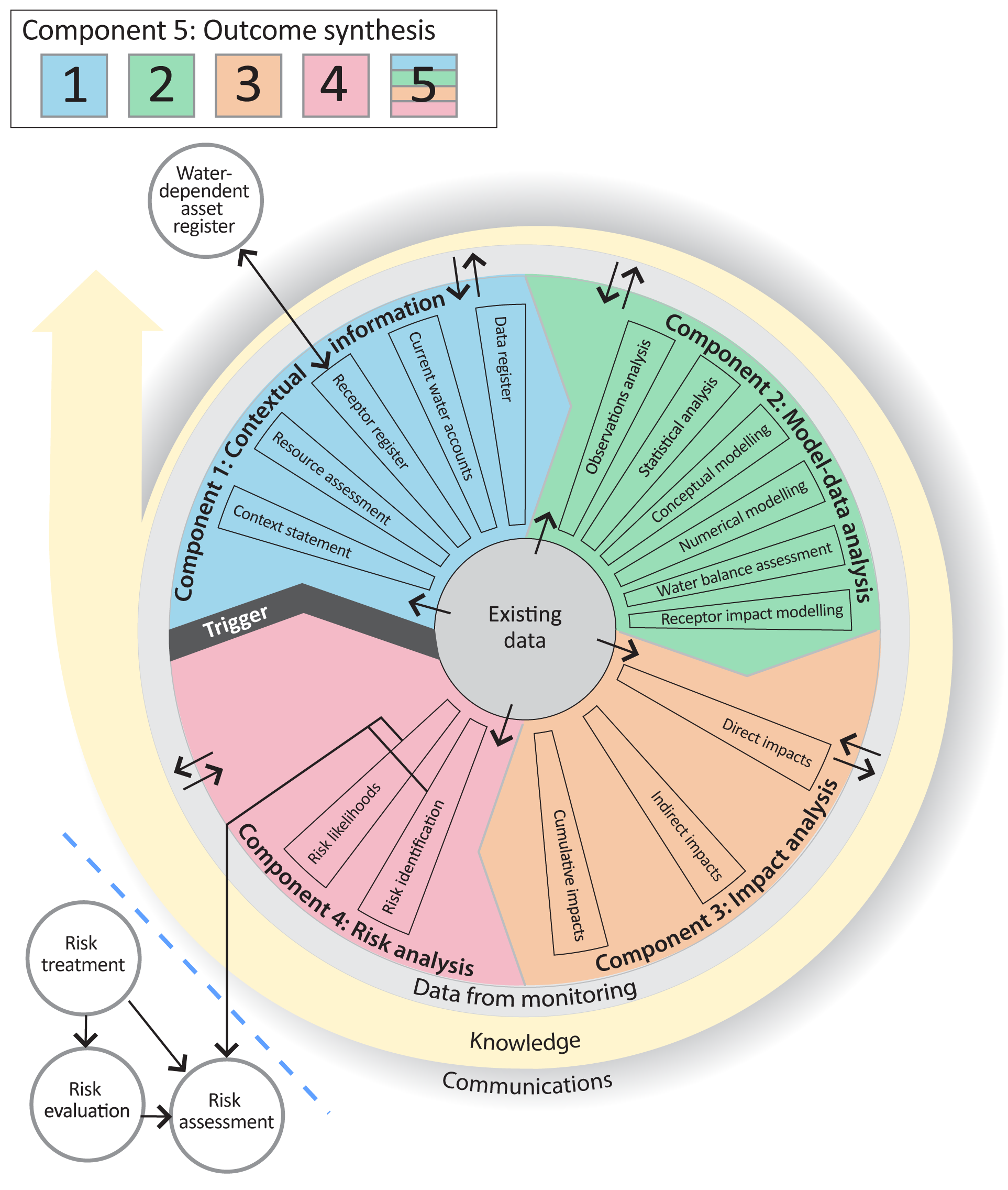
Figure 1. Schematic diagram of the bioregional assessment methodology. The methodology comprises five components each delivering information into the assessment and building on prior components thereby contributing to the accumulation of scientific knowledge. The risk identification and risk likelihood components are conducted within a bioregional assessment and may contribute to risk evaluation, risk assessment and risk treatment undertaken externally
2.2 Definition of a bioregion
A 'bioregion' is usually defined as an area of broadly comparable climate, lithology, terrain, geography, vegetation, fauna and land use attributes. However, this definition is too narrow for use here.
In the BA methodology, a bioregion is:
the land area that constitutes a geographic location within which is collected and analysed data and information relating to potential impacts of coal seam gas or coal mining developments on receptors identified for key water‑dependent assets.
In this context, a bioregion is the area within an arbitrarily defined boundary on the land surface that takes into account the spatial domain of influence linking water-related impacts of CSG and coal mining development to the material direct, indirect and cumulative impacts on receptors.
For the convenience of processing large volumes of data and clarity of presentation, a bioregion may be divided into a set of 'sub-regions'. Each sub-region is an identified area wholly contained within a bioregion that enables convenient presentation of outputs of the BA largely independent from other sub-regions.
Complex relationships between the geographical distribution of coal resources, water resources, assets and receptors can make the selection of a bioregion boundary difficult. For example, various configurations of ecosystems, water uses, and complex below-ground surface geology may be encompassed. Downstream and distant impacts and connectivity pathways between distant ecosystems need to be considered. Primary sources of data to define bioregion boundaries include water catchments (as defined by the Bureau of Meteorology), coal basins (Geoscience Australia) and natural resource management boundaries (SEWPaC, 2010). Final determination of the location of bioregional boundaries lies with government based on advice from the IESC.
2.3 'Far-field' impacts beyond a bioregion boundary
There may be limited circumstances where isolated impacts may occur over restricted areas at great distances from a CSG or coal mining development. Alternatively, impacts may occur across several bioregions or sub-regions such as in the eastern Australian coal fields of Queensland and New South Wales. For example, direct drawdown effects on a watertable can change the availability of groundwater or surface water, which in turn may cause indirect impacts on water-dependent assets such as springs elsewhere in a basin. Furthermore, some cumulative impacts may have the greatest potential to be significant outside the prescribed bioregion boundary.
Under these circumstances, it may be unfeasible or impractical to extend a bioregion boundary to incorporate 'far-field' and isolated impacts. In this case, the impacts and risks are to be evaluated by the BA methodology as though the assets and receptors were inside the bioregion boundary. The analysis of impacts and risks is to be undertaken and included in the BA reporting process and the workflow updated to reflect the judgment and decisions as to why the boundary was not extended to encompass all impacts areas.
2.4 Temporal scales for assessing impact
The impacts of dewatering and depressurisation due to CSG and coal mining may reach far into the future. For example, groundwater systems may take decades to centuries to reach a new steady state. Therefore, all modelling time domains must be of sufficient duration that model dynamics have achieved quasi-equilibrium to within a stated tolerance. In addition, as the timescale of impacts increases, external factors such as climate change, population growth and agricultural expansion will interact with impacts from CSG and coal mining developments. As far as practicable, and within the bounds of uncertainties, BAs need to consider these interactions when framing advice. For example, where dewatering for coal production materially impacts a wetland over a 50-year life-of-mine, climate change impacts on that wetland may also need to be taken into account if long-term rainfall change is a co-factor in those impacts. For consistency across BAs, the same climate change scenarios must be used by all assessments and recorded or a specified general climate model output is to be used (e.g. the CSIRO Mk III GCM output).
Development pathways of coal resource development for bioregions must take into account all available information on CSG and coal mining exploration and production time frames. It is recognised that development timelines of CSG or coal mining development projects are subject to economic and technological determination with associated uncertainties. However, judgment is required to specify particular and realistic development pathways for consideration in a BA. Such considerations will include all stages of mine life including exploration, production, closure and mine legacy issues.
2.5 Components of the methodology for bioregional assessments
The BA methodology is undertaken in five components:
- Component 1: Contextual information
- Component 2: Model-data analysis
- Component 3: Impact analysis
- Component 4: Risk analysis
- Component 5: Outcome summary.
These components should be concurrent or largely overlapping in time, with each component designed to build on information gathered from prior components. In this way, information acquired during the contextual information and model-data analysis components is synthesised to develop the impact and risk analyses. It should be noted that the definition of 'model' used in this methodology includes all scientific definitions of the term model: that is, conceptual, numerical, analytical, semi-quantitative and qualitative representations of physical, chemical, biological and ecological processes.
As noted throughout this methodology, the degree to which each component achieves 'best practice' depends on data availability, model completeness and knowledge status for different bioregions. Deviations from best practice, due to insufficient data, inadequate models or lack of knowledge, is to be recorded in the workflows, and judgment exercised as to how best proceed and the BA completed. In all cases, though, the BA is a statement of the current state of best scientific knowledge concerning impacts of CSG and coal mining development on water-dependent assets within bioregions.
Monitoring and review comprise an important additional program that improves the assessment over time as periodic updates or revisions of BAs occur. Given the development of a monitoring program, the BA methodology anticipates consideration and evaluation of the review frequency of bioregional advice as part of a BA. This additional program will be concerned with ongoing acquisition of data for improvement in model performance and developing a review process for iterative improvement of a BA in a given bioregion. The monitoring and review program must also advise on the costs and benefits of recommended additional work to ensure that monitoring effort maximises a reduction in uncertainty in a future update of a BA.
Advice that BAs should provide on the monitoring program includes:
- an explicit description of knowledge gaps
- specifications for sampling
- periodic evaluation of results
- establishment of clear links between sampling and updating of model outputs
- locations and types of measurements to maximally reduce uncertainties in impacts
- identified development points for conceptual and numerical models
- where management authorities and companies can improve monitoring
While information flow is sequential from Component 1 through to Component 5, most activities undertaken within each component must be conducted in parallel with other components. For example, work on impact analysis (Component 3) and risk analysis (Component 4) would be initiated at the same time as work conducted to compile contextual information (Component 1) or data analysis and numerical modelling (Component 2). This is necessary because the impact and risk analyses must be framed in context of the available data and model outputs, while data evaluation and model conceptualisation and development must consider the requirements of impact and risk analyses. Iteration between components ensures that the information requirements of all components are met. In this way, the required knowledge base associated with CSG and coal mining development (namely, improved understanding of the direct, indirect and cumulative impacts on receptors and risks to those receptors and assets) grows during application of the BA methodology. Using a synthesis of information from key observations, outputs from data analysis and models, and a quantitative analysis of uncertainties, a risk analysis is obtained based on the best available information for a bioregion. In applying the BA methodology, new data will be analysed, and uncertainties in observations, datasets and models will be characterised. Transparency and objectivity are the cornerstones of the BA methodology with data and analytical techniques fully reported.
In five components, the BA methodology provides steps to assess the impacts of CSG and coal mining development within a bioregion for both current and future development pathways. The culmination of the first three components of the BA methodology is an integrated assessment of the impact of CSG and coal mining development on receptors identified for key water-dependent assets of a bioregion. This assessment will inform Component 4, the risk analysis. The impact and risk analyses are conducted for 'receptors' identified for all key water-dependent assets. The final component is the reporting and delivery of outcomes in products; the enduring process and products from a BA will ensure the lasting benefit of this approach.
2.5.1 Contextual information
The contextual information component (Component 1) provides a series of information products that describe the character of the bioregion, and are used to support qualitative or quantitative assessment of impact and risk. Contextual information includes all relevant datasets, background studies and subsidiary information on the ecology, hydrology, geology and hydrogeology of a bioregion that is necessary to interpret the impacts and risk analyses. Sub-components of the contextual information component are described in Sections 2.5.1.1 to 2.5.1.6 with more detailed guidance on selected components provided in Chapter 3 .
2.5.1.1 Context statement
The context statement summarises the current extent of knowledge on the ecology, hydrology, geology and hydrogeology of a bioregion and provides baseline information. In some bioregions the context statement may be the first available summary of information relevant to understanding the regional context of water resources within which CSG and coal mining development is occurring.
The context statement is a collation of all information regarding a bioregion that is relevant to interpret the impact and risk analysis and outcomes of the BA. It characterises geology, climate, land use, hydrology, current water accounts, water quality, geomorphology, geography and land use of a bioregion. The statement should include materially relevant characteristics of a bioregion that are needed to adequately interpret output from ecological, surface water and groundwater datasets and models, and from this develop improved knowledge of whole-of-system functioning.
2.5.1.2 Coal seam gas and coal resource assessment
The CSG and coal resource assessment provides an evaluation of CSG and coal mining development over time, current reserves, and current and expected future levels of exploitation from exploration and approval through to production and mine closure. The impacts of these mine life stages on water dependent assets may occur over multiple decades and extend hundreds of years. These are considered in the model-data analysis (Component 2). Information or assumptions used to define the CSG and coal mining development pathways, such as mine type, mining methods and management, must be specified. For example:
- use of caving
- open-cut long-wall mining methods
- void treatment
- consequences on land surface through subsidence
- dewatering management methods
- water treatment
- decommissioning methods
- pit lake management plans
- CSG drilling methods including hydraulic fracturing and well stimulation
- treatment of associated water
- decommissioning and sealing wells.
The information on CSG and coal resource assessment will be used to define current and future development pathways to be used in the numerical modelling (Section 2.5.2.5). Further details on the CSG and coal resource assessment are provided in Section 3.3.
2.5.1.3 Water-dependent asset register
The water-dependent asset register consists of the identification, description and listing of all significant water-dependent assets within the bioregion. A water-dependent asset is defined as an entity within a bioregion where the particular characteristics can be ascribed value and which can be clearly linked directly or indirectly to a dependency on water quantity or quality. The asset register needs to consider the identification and representation of different types of water-dependent ecosystems within a bioregion including taking into account developments in a national freshwater bioregional classification and species distribution schemes (e.g. the TraCK program; Kennard et al., 2010) such as those under discussion by the Commonwealth Environmental Water Holder and the Commonwealth Environmental Water Scientific Advisory Panel. Further guidance is provided in Section 3.4 .
2.5.1.4 Receptor register
The receptor register contains a catalogue of all receptors for which direct, indirect and cumulative impacts are to be assessed through the BA methodology. One or more receptors are registered for each water-dependent asset. A receptor is defined as a discrete attribute or component of a water-dependent asset that may be measurably impacted by a change in water quantity or quality resulting from CSG or coal mining development. Further guidance is provided in Section 3.5 .
2.5.1.5 Current water accounts and water quality
The current water account statement provides an assessment of:
- water resources (rainfall, runoff, evapotranspiration, surface water, groundwater, groundwater recharge and discharge)
- water infrastructure (weirs, dams, offtakes, bores)
- water allocations, licences, extractions and use within the bioregion broken down by sector (such as agriculture, forestry, urban, industry, mining).
Information on surface water and groundwater quality is required, particularly baseline condition and the identification of existing water quality threats and trends, and current measures to address them. A discussion on groundwater composition should cover naturally occurring gases in groundwater that not only identifies the source aquifer and age of recharge (National Research Council, 2010) but also indicate existing connections with coal strata.
2.5.1.6 Data register
The data register is a library of all datasets used in the model-data analysis and risk analysis. It describes their provenance, history, metadata and an analysis of confidence or uncertainty in these data expressed as far as possible in quantitative terms (standard deviations, root mean square error, coefficient of variance or other forms). Metadata are provided to describe all data and datasets used in the numerical modelling, including driver data of models and initial and boundary conditions for model simulations.
The data register includes the provision of advice on data deficiencies and if new sampling programs are required. It should be noted that the use of currently available observations as constraints on numerical models for the purpose of assessing impacts of regional dewatering on receptors will push the restricted information content of these datasets to their limit. Existing datasets would be expected to be augmented with new monitoring programs to be able to improve the quality of advice from successive updates of a BA.
2.5.2 Model-data analysis
The model-data analysis component of the BA evaluates and synthesises information obtained from observations (data) and the understanding of processes from models to develop a qualitative or quantitative description of hydrological relationships between coal seams and associated anthropogenic and ecological receptors. Confidence in inferences (based on models and data) must be assessed, and this uncertainty analysis used (in turn) for estimating impacts and risks in components 3 and 4.
2.5.2.1 Observations analysis
The observations analysis is an analysis and synthesis of data to determine key characteristics and processes of receptors and assets within a bioregion. The data may be used directly, or as input to interpretation tools.
The observations analysis includes an assessment of all forms of data errors and uncertainties; the spatial and temporal resolution of observations; and algorithms used in development of derived datasets (e.g. remote sensing datasets). It requires development of summary statistics that describe the nature, variation and uncertainty for all datasets – including observational, forcing and other data. It also incorporates an assessment of data gaps and requirements for new sampling.
2.5.2.2 Statistical analysis and interpolation
The aim of the statistical analysis and interpolation is to develop a quantitative understanding of the ecology, hydrology, geology and hydrogeology of the bioregion based on available observations alone. The statistical analysis relies on the observations analysis (Section 2.5.2.1) to characterise the state of knowledge of groundwater and surface water resources based on interpretation and analysis of data. The statistical analysis and interpolation differs from the observations analysis in that it attempts to characterise knowledge of the water resources of a bioregion or sub-region where observational data exist and then uses this data to interpolate into data-sparse locations. Importantly, the statistical analysis will provide an evaluation of the confidence in the datasets and the characterisation of statistical errors in observations used to assess impacts. This information contributes to the robustness of the interpretation of impacts and risks that can be achieved using existing information. The statistical analysis will identify areas that potentially cannot be characterised without collection of additional data.
Interpolation, filtering and inference methods are well known and used regularly. For example, in geology, hydrogeology and groundwater observations, geostatistical methods are well developed. In surface water hydrology, prediction tools for spatial processes are available. For ecology, spatial modelling of species distributions and their responses have been developed (e.g. TRaCK; Kennard et al. (2010)).
The interpolated fields from statistical analyses can be used in the numerical modelling as a means of constraining model states and parameters. It includes the application of spatial analysis and interpolation methods for assessing the distribution and uncertainties in aquifers, aquitards, rivers, wetlands and groundwater-dependent ecosystems and coal-bearing strata across the bioregion. It provides a supplementary information source (in addition to output from the numerical modelling) and, in some cases, may provide interpolated spatially distributed data needed to constrain dynamics of the numerical models.
The statistical analysis includes an assessment of data gaps and the design of a sampling network needed to maximally reduce uncertainties through future observations and field sampling programs. Such an assessment must be undertaken even if the spatial and/or temporal distribution of data is insufficient to allow statistical treatment as it will inform an assessment of the appropriate level of effort required for data collection and system conceptualisation in subsequent updates of the BAs.
2.5.2.3 Conceptual modelling
A conceptual model is a qualitative description of the systems and sub-systems within a bioregion. It describes the set of hypotheses as to how these systems interact with impacts of CSG and coal mining development and link closely with the qualitative, semi-quantitative and quantitative models used to describe impacts on receptors. Conceptual models in the BAs describe the causal pathway from CSG and coal mining development to the direct, indirect and cumulative impacts on receptors. They may comprise broad-scale coarse-resolution conceptual models within which fine-scale conceptual sub-models are nested to take into account the range of scales over which processes occur. Conceptual models developed for the BA must be comprehensive and detailed enough to satisfy known characteristics of interactions in a system, cognisant of the availability of data.
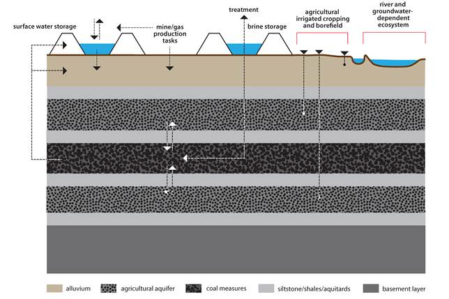
Figure 2. An example conceptual model of a bioregion
The conceptual model shall include:
- broad concepts of inflows and outflows to a bioregion in surface water and groundwater domains
- the location of catchment boundaries (including groundwater divides) and ecological distributions of receptor species
- the response functions of anthropogenic and ecological receptors
- the identification of receptors sensitive to changes in flow, groundwater levels and/or water quality.
Consideration of the timing of flow events, and of the impacts of seasonal and longer term fluctuations, is also a key component of the conceptual model. The Australian classification of unimpeded streams and rivers (Kennard et al., 2010) should be consulted to develop a baseline of flow regimes and their variance in space and time. Furthermore, evaluation of current status of a bioregion, or parts of it, in terms of degree of disturbance or perturbation of the natural system, is an important part of understanding the nature of baseline conditions and variation that exist prior to the commencement of any new CSG or coal mining development.
Conceptual models are iterative tools and, as knowledge improves incrementally during the course of the assessment, the number of possible conceptual models (or alternative hypotheses) decreases and the confidence in any individual conceptual model and their nested sub-models increases. The necessary changes in conceptualisation will cascade into the water balance assessment and into the fundamental parameters of numerical models; two- and three-dimensional visualisations will assist in communicating these concepts.
2.5.2.4 Water balance assessment
The water balance assessment is integral to a conceptual model and represents an analysis, over specific time periods, of:
- water inputs and allocations
- river and surface water management
- groundwater recharge and discharge
- water needs of floodplains, wetlands and groundwater-dependent ecosystems
- surface water – groundwater exchange
- natural surface water and groundwater flow
- the role of wetlands and floodplains in determining a bioregion water balance
- the impact of agricultural, forestry and urban or peri-urban development on the availability and use of water resources.
The provision of current data and/or estimations of all surface water and groundwater extraction in the bioregion (including that for current coal mining and CSG extraction) is a critical part of this assessment, together with an identification of the river reach or source aquifer, the water use, the measurement and estimation methods used to calculate the extracted volume, and the legislation that covers each form of extraction. The water balance assessment must include an estimation of the impacts of future water extractions, such as the activation of unused entitlement and the increase in use not subject to entitlement (e.g. extraction for stock and domestic purposes, uncapped bores and interception activities if relevant). The impacts of anticipated increases in extraction related to CSG and coal mining activities, as well as collateral impacts on the water balance extending beyond the water body in which dewatering activities are occurring, should also be assessed. Water balances developed for CSG and coal mining developments are likely to be in use by industry for active or proposed projects or can be estimated from expected production data, state agency datasets and environmental impact assessments.
Multiple water balances are required to represent both a bioregion and the time periods in which the anticipated activities will occur. A water balance is dynamic and requires an analysis of its temporal and spatial variation (due to natural and anthropogenic influences). As for conceptual models, water balance assessments are iterative and, with increased understanding of a bioregion, the water balance assessment will need to be refined.
2.5.2.5 Surface water and groundwater numerical modelling for current and future development pathways
Best-practice surface water and groundwater numerical modelling requires:
- a conceptual model
- representative data (both spatially and temporally) to inform parameterisation and calibration of models
- comprehensive flow modelling of groundwater dynamics for aquifers, coal seams and aquitards within the bioregion based on availability of data
- explicit connectivity of processes between coal seam(s), overlying and underlying aquifers, and assets that depend on surface water and groundwater
- fully coupled surface water – groundwater interactions using present-day climate forcing, water balance and land use or land management datasets
- qualification or quantification of conceptual and numerical uncertainties.
A numerical flow model is required to represent a complex hydrogeological system including physical flow processes, multiphase flow, calibration of model dynamics against multiple datasets, predictive runs and propagation of uncertainties. This requires development of fully coupled flow models that represent surface water – groundwater interactions and that update surface water and groundwater states dynamically during the simulation. The numerical modelling should conform to the checklist and guidelines of appendices F and H of Middlemiss (2001) and Tables 9-1 and 9-2 of Barnett et al. (2012). Simulation run times must be sufficient to represent all transient states in the model in order that slow processes and state variables (e.g. for groundwater dynamics) approach equilibrium to within a stated tolerance (e.g. within 1% of state variables such as hydraulic head). The time period for the modelling also needs to be relevant to the receptor of interest. Time periods extending for decades must account for climate change effects on model dynamics taking into account relevant Intergovernmental Panel on Climate Change scenarios.
The numerical modelling generates results for both current and future development pathways, which are defined in the CSG and coal resources assessment (Section 2.5.1.2 and Section 3.3). The future development pathways represent a range of plausible development pathways across the stages of coal or CSG extraction.
A key component of the numerical modelling is the quantification of statistical uncertainties associated with model outputs, covered in detail in Chapter 4. Model outputs and their uncertainties are to be propagated through the receptor impact modelling and the risk analysis.
2.5.2.6 Receptor impact modelling
Ecological knowledge and data are essential to developing an understanding of the impacts of coal seam depressurisation and dewatering on receptors contained within water-dependent assets. Extensive work already carried out by existing programs – for example technical assessments for water resource planning, the National Atlas of Groundwater Dependent Ecosystems, the Queensland GDE Mapping Project, Aquatic Conservation Assessments, and High Ecological Value Aquatic Ecosystem Project – provide fundamental data forming the foundations of the BAs and underpin the receptor impact modelling.
The impacts of CSG and coal mining developments are mediated through changes in water resources requirements and/or dependencies of receptors. Integral to receptor impact modelling are consideration of the dependence of receptors (and through them asset values) on groundwater and surface water; the attributes of those dependencies; and the resilience, resistance, vulnerability and response of receptors (and hence assets). To put these impacts in context (Section 2.5.3) requires information from the contextual component of a BA.
Output from the numerical modelling (Section 2.5.2.5) is used as input into qualitative, semi-quantitative or quantitative receptor impact models. The conceptual models (Section 2.5.2.3) are used to guide development and implementation of the receptor impact models. These models are required to estimate the direct, indirect and cumulative impacts on anthropogenic and ecological receptors. The range and variety of receptor impact models will vary among bioregions, depending on the type of water-dependent assets and receptors contained therein. The large majority of receptors would be expected to be near or at the surface. However, some receptors (e.g. stygofauna and agricultural wells) may be at depth.
Whether receptor impact modelling is qualitative or quantitative will depend on the level of understanding of the relationship between a receptor and water quality or quantity, and on output from the surface water and groundwater modelling. Estimation of impacts may be semi-quantitative where some components can be determined numerically with some confidence, but other components are less precisely defined or are not linked to numerical models. Qualitative models may be appropriate for estimating impacts on hydrological processes such as recharge. Conceptual models may be appropriate for some ecological receptors such as breeding success where the links between numerical modelling data outputs and impacts are less straightforward. Expert judgment is required in these cases and all decisions based on judgment must be recorded in the workflow for external scrutiny.
2.5.3 Impact analysis
All receptors contained in the receptor register within each water-dependent asset will be assessed in the impact analysis. This component will report the direct, indirect and cumulative impacts – and associated uncertainties – obtained in the surface water and groundwater numerical modelling, and the receptor impact modelling (Section 2.5.2.6), for current and future development pathways (Section 2.5.2.5 and Section 4.4). The impact analysis needs to consider the potential effects and consequences of CSG and coal mining development, thereby estimating the severity of impacts on the hydrogeology, as well as the causal chain connecting hydrogeology, surface water hydrology and ecological processes with receptors. Alternatively, the causal chain may link the application of desalination permeate, and the production, storage and disposal of brine, with agricultural receptors such as irrigated crops, alluvial aquifers or receiving aquifers from reinjection programs. As noted in the previous section, it is recognised that explicit, calibrated and validated models of many biophysical and ecological processes that impact on receptors as a result of dewatering and depressurisation of coal seams may not be sufficiently comprehensive and quantitative for high-confidence assessment of impacts on receptors. Therefore, the impact analysis is required to draw on all available information sources – including external peripheral datasets, empirical relations, auxiliary studies, literature reviews and any other sources – in order to assess receptor impacts using a 'multiple lines of evidence' approach. Where uncertainties are too large for quantitative assessment of impacts, qualitative assessments are to be provided with accompanying logic structure and evidence recorded in the workflow.
The integrated nature of the impact analysis requires clear statements of logic, evidence and confidence regarding impacts on receptors. A key challenge is isolating the impacts of CSG and coal extraction from the aggregate and incremental impacts from other sources (e.g. agriculture) that may impact on receptors over time. Where uncertainties are too large to assess cumulative impacts, this must be recorded in the BA workflow and advice must be given as to the research, sampling and monitoring programs that are needed to reduce these uncertainties substantially. An additional difficulty will be to differentiate between 'impacts' and 'change'. Baseline monitoring of systems coupled with receptor impact modelling are the tools by which natural variability of a system's response to dynamic forcing (e.g. by climate) is to be distinguished from changes that can be linked to impacts. Cumulative impacts of proposed new CSG and coal mining developments are to be considered at least over the time horizon of development pathways and longer if impacts occur beyond this.
2.5.4 Risk analysis
The IESC endorses the use of risk-based assessments as the best approach in providing scientific advice on proposed CSG and coal mining developments and their impacts on water-dependent assets. Risk is the 'the effect of uncertainty on objectives' where effect is 'a deviation from the expected' and uncertainty 'the state, even partial, of deficiency of information related to, understanding or knowledge of an event, its consequence, or likelihood' (AS/NZS ISO 31000:2009 Risk management – principles and guidelines).
A risk analysis undertaken within a BA is concerned with likelihood of impacts on receptors contained within identified water-dependent assets and does not consider other risks (e.g. to landscape functioning and biodiversity).
An emphasis on rigorous assessment and propagation of uncertainty in BAs is key to their ability to provide robust scientific advice on risks. BAs must provide sufficient scientific advice as to the level of risk associated with impacts on water-dependent assets (e.g. Matters of National Environmental Significance and other important ecological and cultural water features). The analysis of risk is a key outcome of an assessment that utilises both:
- output from model-data analysis to define consequences via direct, indirect and cumulative impacts
- uncertainties to provide information on likelihoods required by the risk analysis.
Qualitative risk analysis methods (where likelihoods are provided in a descriptive way) provide a rapid and simple method for assessing first order or comparative risks to receptors – and subsequently key water-dependent assets – from CSG and coal mining development. With increasing reliability of observations and models, and adequate spatial and temporal distribution of observations, semi- or fully quantitative risk analyses are to be used to provide transparent, consistent and robust information on the likelihood of specified events occurring, and the potential consequences on receptors and, hence, water-dependent assets. The events under consideration within a BA include depressurisation and dewatering of coal seams; potential regulated and unregulated discharge of stored worked water on mine sites; and fate of CSG permeate and brine derived from treatments of associated water. A key component to the analysis is the use of formal logic procedures to ensure that the assignment of likelihoods and consequences is transparent and consistent. In particular, developing correct conditional statements for the likelihood of events occurring (Barry, 2011) is important to achieving accurate qualitative or quantitative risk analyses and assessments.
To ensure consistency between risk-related work undertaken among bioregions, the BA methodology requires compliance with the ISO 31000:2009 standard; however, full application of the ISO 31000:2009 standard is outside scope, terms of reference and budget of a BA. The components of the ISO risk assessment to be undertaken in a BA are:
- risk identification: the identification of risks within a bioregion through understanding exposure of receptors to impacts from CSG and coal mining development and how this exposure may affect values of water-dependent assets
- risk analysis: an analysis that combines likelihood of event occurrence, uncertainties associated with impacts, and information from the risk register to generate (i) a consequence table describing the nature of impacts, and (ii) a risk rating matrix describing the severity of impacts.
- The risk evaluation and risk treatment components of the ISO 31000:2009 Risk Management Standards are the role of the proponent in the first place, and of Government, as the regulator of the proponents activities. For Government, risk evaluation and treatment requires careful consideration of a number of non-scientific matters that are outside the scope of the BA.
2.5.5 Products
The outputs of the BAs are five products that must contain at a minimum the following:
- Product 1: 'Bioregional assessment of NNNN basin/MMMM catchment: contextual information' contains sections on:
- context statement
- CSG and coal resource assessment
- water-dependent asset register
- receptor register
- current water accounts and water quality
- data register.
- Product 2: 'Bioregional assessment of NNNN basin/MMMM catchment: model-data analysis' contains sections on:
- observations analysis
- statistical analysis and interpolation
- conceptual modelling
- two- and three-dimensional visualisation
- water balance assessment
- surface water and groundwater numerical modelling for current and future development pathways
- receptor impact modelling.
- Product 3: 'Bioregional assessment of NNNN basin/MMMM catchment: impact analysis' contains sections on:
- direct impacts on receptors
- indirect impacts on receptors
- cumulative impacts on receptors.
- Product 4: 'Bioregional assessment of NNNN basin/MMMM catchment: risk analysis' contains sections on:
- risk identification
- risk analysis
- Product 5: 'Bioregional assessment of NNNN basin/MMMM catchment: outcome summary' contains sections that summarise the results from components 1 to 4:
- summary of contextual information
- summary of model-data analysis
- summary of impact analysis
- summary of risk analysis.
All data syntheses and databases are to be made available through existing Commonwealth Government data access systems linked to the Office of Water Science (Department of Sustainability, Environment, Water, Population and Communities). All unencumbered tools and model code, procedures, routines and algorithms and all forcing, boundary condition, parameter and initial condition datasets used to generate the BAs are to be made publically available. Where commercial models are used, complete details of name, type, version and ancillary data are to be provided to a sufficient resolution that a third party in possession of these models could repeat the analyses.
Publication of the workflow associated with each BA is also required. This workflow comprises a record of all decision points along the pathway towards completion of the assessment, gaps in data and modelling capability, and provenance of data.
