For this Assessment, a pragmatic coupling of three models was developed. The models consist of a regional groundwater model and an alluvial groundwater model to simulate the impact on the groundwater systems, and a rainfall-runoff model to simulate the impact on the surface water systems of the subregion. The individual models have different spatial and temporal resolutions which requires a set of customised processing steps to upscale or downscale model data to allow the models to be linked.
The regional groundwater model is an analytic element model (referred to as GW AEM), designed to simulate the change in drawdown at the receptors associated with the groundwater bores in the Gloucester geological basin weathered zone, and to provide the change in groundwater level underneath the Avon and Karuah alluvia. The latter provides the lower boundary condition for the alluvial groundwater models. For both alluvial systems a MODFLOW model was developed (referred to as GW ALV) to simulate the change in drawdown on receptors associated with the alluvium and the change in surface water – groundwater flux. This flux is taken into account in the AWRA-L surface water model generated streamflow. The change in a number of hydrological response variables is modelled at the surface water receptor locations.
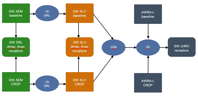
Figure 3 Model sequence for the Gloucester subregion
GW AEM = regional analytic element groundwater model; GW ALV = alluvial MODFLOW groundwater model; AWRA-L = rainfall-runoff model; SRL = surface weathered and fractured rock layer; dmax = maximum difference in drawdown for one realisation within an ensemble of groundwater modelling runs, obtained by choosing the maximum of the time series of differences between two futures; tmax = year of maximum change; Dh = change in groundwater level; DQb = change in surface water – groundwater flux; Qt = total streamflow; DHRV = change in hydrological response variable
Figure 3 shows in more detail the sequencing of the different models. In the GW AEM baseline coal resource development model the impact of the historical coal mines and coal mines commercially producing coal as of December 2012 are simulated. The GW AEM CRDP simulates the impact of the coal resource development pathway (CRDP), which is the impact of the baseline as well as those developments that are expected to begin commercial production after 2012. The difference in simulated drawdown of those two runs will be the simulated impact of the additional coal resource development on the groundwater receptors in the shallow weathered and fractured rock layer of the Gloucester geological basin.
The impacts simulated by the GW AEM underneath the alluvium feed into the alluvial groundwater models for the Avon and Karuah rivers. The difference in simulated drawdown of those two model runs is the simulated impact of the additional coal resource development on the economic and ecological receptors in the Avon and Karuah alluvium. The GW ALV models for the Avon and Karuah rivers also simulate time series of the change in surface water – groundwater flux, ![]() , for the surface water catchments associated with receptor nodes in the AWRA-L model as:
, for the surface water catchments associated with receptor nodes in the AWRA-L model as:
|
|
(1) |
where ![]() and
and ![]() are the baseflows under baseline and CRDP, respectively, at time
are the baseflows under baseline and CRDP, respectively, at time ![]() .
.
The AWRA-L baseline run simulates streamflow at surface water receptors incorporating the effect of commercially-producing open-cut coal mines at December 2012. The AWRA-L CRDP run simulates streamflow at the surface water receptors incorporating the effect of the baseline open-cut coal mines plus the additional coal resource development. The difference in total streamflow, ![]() is obtained as:
is obtained as:
|
|
(2) |
where ![]() and
and ![]() are the total streamflows under baseline and CRDP, respectively. The time series of
are the total streamflows under baseline and CRDP, respectively. The time series of ![]() are summarised in the nine hydrological response variables to highlight different aspects of the hydrograph. These hydrological response variables will inform the receptor impact models for the surface water receptors.
are summarised in the nine hydrological response variables to highlight different aspects of the hydrograph. These hydrological response variables will inform the receptor impact models for the surface water receptors.
