The assessment identified potential hazards (Dataset 6) associated with coal resource development that could result in hydrological changes, such as aquifer depressurisation due to groundwater extraction. Hazards in scope were further assessed by first estimating relevant hydrological changes through groundwater modelling and then identifying potential impacts on, and risks to, water-dependent landscapes and assets (described in the following sections).
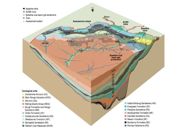
Impacts to water-dependent landscapes and assets are mostly caused by changes to groundwater in the regional watertable. The regional watertable represents the upper groundwater level within the near-surface aquifer, and may exist in different geological units or layers, as shown in Figure 3 and Figure 4. Near the two additional coal resource developments it occurs in the alluvium, as well as the Main Range Volcanics and the Walloon Coal Measures. Springs and groundwater bores may be affected by hydrological changes in deeper geological layers, which may have ecological consequences for surface ecosystems surrounding springs.
ACRD = additional coal resource development
Data: Bioregional Assessment Programme (Dataset 1, Dataset 3, Dataset 4); Queensland Department of Natural Resources and Mines (Dataset 2); Queensland Office of Groundwater Impact Assessment (Dataset 5)
After the potential hazards were identified, the chain of events that commonly arise from coal resource development activities were analysed and categorised into four main causal pathway groups (Figure 4):
- ‘Subsurface depressurisation and dewatering’ includes extraction of groundwater to enable CSG extraction and dewatering of open-cut mine pits. It has the potential to directly affect the regional groundwater system, and indirectly affect surface water – groundwater interactions in aquifer outcrop areas. Potential effects are likely to be in the medium term (5 to 10 years) to long term (10 to 100 years).
- ‘Subsurface physical flow paths’ includes activities where physical changes to the rock mass or geological layers create new physical paths that water may potentially gain access to and flow along. Potential effects are in the medium to long term and are likely to be restricted to aquifer or aquifer outcrop areas, but can also affect connected watercourses within and downstream of mines.
- ‘Surface water drainage’ includes activities that physically disrupt the surface and near-surface materials (vegetation, topsoil, weathered rock). Medium- to long-term cumulative effects are possible for watercourses within and downstream of development. Activities may include construction of diversion walls and drains, interception of runoff, realignment of streams, and groundwater extraction for CSG production or underground coal mining leading to subsidence of land surface.
- ‘Operational water management’ involves modification of surface water systems to allow storage, disposal, processing and use of extracted water. Potential effects are likely to be in the medium to long term and include watercourses in aquifer outcrop areas that are within and downstream of operations.
Hazards not in scope include those that are adequately addressed by site-based risk management, such as accidents.
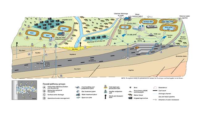
This schematic diagram is not drawn to scale. To improve clarity the potentiometric surface for the deeper confined aquifer is not shown. The inset schematic shows hydraulic fracturing of a coal seam, where a mixture predominantly composed of water (blue) and sand (yellow), with minor amounts of chemical additives, is injected at high pressure into the well to produce small cracks in the coal (lighter grey zone). This process enhances the permeability of the coal seam, enabling larger volumes of gas and water to be pumped from the well.
Conceptual modelling, product 2.3 (Holland et al., 2016) Groundwater numerical modelling, product 2.6.2 (Janardhanan et al., 2016) Developing a conceptual model for causal pathways, submethodology M05 (Henderson et al., 2016) Systematic analysis of water-related hazards associated with coal resource development, submethodology M11 (Ford et al., 2016) Impact Modes and Effects Analysis (hazard analysis) for the Maranoa‑Balonne-Condamine subregion (Dataset 6)FIND MORE INFORMATION
