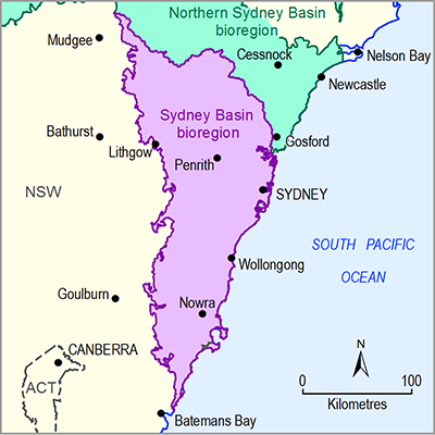
The Bureau of Meteorology is mandated to produce a National Water Account (NWA), and has undertaken a NWA for the Sydney region each year since 2009–10 (Bureau of Meteorology, 2011, 2012, 2013, 2014, 2015). The NWA for the Sydney region does not include groundwater volumes in the water accounting statements because groundwater constitutes a negligible component of water rights (<6%) in the region, primarily for stock and domestic purposes (Bureau of Meteorology, 2014), with the percentage of actual extractions less than this. It does provide contextual information on groundwater resources and management.
Production of the NWA for the Sydney region involves close collaboration with the NSW state agencies responsible for water data collection. In particular, DPI Water (formerly NSW Office of Water) and WaterNSW (formerly Sydney Catchment Authority and State Water Corporation) provide data, check numbers and review sections of the report to ensure that it is the best possible summary of the annual water situation given the available information.
To construct an annual groundwater account, information about the annual inflows, outflows, storages and management context are needed for the reporting region.
Inflows broadly translate into estimates of annual recharge, including the volume of rainfall that infiltrates to an aquifer and/or contributions from other water sources (e.g. river recharge). At a regional scale, recharge is not easy to measure directly and is often modelled or inferred from other data. A groundwater recharge grid has been generated for the Sydney geological basin as part of the Bioregional Assessment Programme (Bioregional Assessment Programme, Dataset 1).
Outflows equate to evapotranspiration (shallow aquifers only), discharges from aquifers to rivers, springs, lakes or the ocean, and water extracted for human consumption. Discharges to rivers (i.e. baseflow) are typically accounted for in surface water accounts; other discharges are not generally quantified. Baseflow is not easy to measure directly and there is a range of methods for estimating baseflow from other data.
Groundwater storages are the aquifers that hold accessible water. Aquifer capacities and stored volumes are often difficult to quantify, especially in fractured rock systems where the volumes and connectivity of fractures are not known. Volumes of groundwater stored in the unconsolidated sediments of coastal sand aquifers and alluvial aquifers are often easier to quantify and storage volumes or sustainable extraction limits are provided in water sharing plans for groundwater resources or in published information from water supply authorities, where the aquifer is an important resource.
Table 4 summarises sources of groundwater data and information available for the Sydney Basin bioregion that could be drawn upon to help construct a groundwater account.
Table 4 Sources of groundwater information for constructing a groundwater account in the Sydney Basin bioregion
|
Custodian |
Data |
Sources |
|
Bioregional Assessment Programme |
Groundwater recharge grid |
Bioregional Assessment Programme (Dataset 1) |
|---|---|---|
|
Groundwater entitlements in the Sydney Basin bioregion preliminary assessment extent (PAE) area |
Bioregional Assessment Programme (Dataset 2) |
|
|
Groundwater management areas |
Bureau of Meteorology (Dataset 3) |
|
|
Bureau of Meteorology |
National water accounts |
Website for the national water accounts, Australia’s most comprehensive water information report (Bureau of Meteorology, 2011, 2012, 2013, 2014, 2015) |
|
National groundwater information system |
Online portal for a spatial database that contains a range of groundwater information submitted by states and territories (Bureau of Meteorology, 2016a) |
|
|
Australian groundwater explorer:
|
Online portal for accessing a wide range of groundwater data, allowing users to visualise and analyse groundwater information within an area of interest. Datasets can be downloaded (Bureau of Meteorology, 2016b). |
|
|
Water entitlements Water markets |
Website for national water markets (Bureau of Meteorology, 2016c) |
|
|
DPI Water |
Water register |
Online portal for accessing the NSW water register which provides public access to information about water licences, approvals, water trading, water dealings, environmental water and other matters related to water entitlements in NSW (DPI Water, 2016a) |
|
Groundwater levels and bore construction logs |
Online portal for accessing all of DPI Water’s groundwater data (DPI Water, 2016b) |
|
|
Water sharing plans |
Online pages about water sharing plans including those already commenced (DPI Water, 2016c) |
|
|
NSW Government |
State legislation:
|
NSW Government website for online publication of legislation (NSW Government, 2016) |

