- Home
- Impact assessment for the Beetaloo GBA region (stage 3)
- Executive summary
The $35.4 million Geological and Bioregional Assessment (GBA) Program is assessing the potential environmental impacts of unconventional gas resource development, to inform regulatory frameworks and appropriate management approaches. The geological and environmental knowledge, data and tools produced by the GBA Program will assist governments, industry, land users and the community by informing decision-making and enabling the coordinated management of potential impacts.
About the region
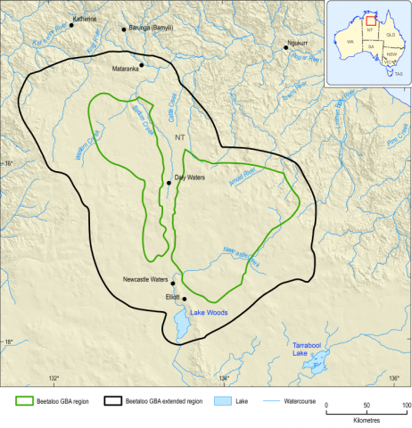
The Beetaloo GBA region covers an area of 28,000 km2 about 500 km south of Darwin in the Northern Territory. The climate varies from tropical in the north to semi-arid in the south. Reflecting this climate pattern, tropical savanna species are found in the north with typical Australian desert species dominant in the south. Land use is mainly beef cattle production, with perpetual pastoral leasehold covering 90% of the land area. The region is sparsely populated; the Wubalawun, Mangarrayi, Murranji, Alawa, Gurungu, Marlinja, Dillinya, Karlantijpa and Mambaliya Rrumburriya Wuyaliya Aboriginal Land Trusts are in or near the Beetaloo GBA region.
The Beetaloo GBA region, which is coincident with the Beetaloo Sub-basin, is prospective for significant unconventional gas resources that include shale and tight gas, with potential for liquid hydrocarbons. The gas industry is in the exploration phase of the development life cycle, and there are no existing petroleum developments. A broader region, the Beetaloo GBA extended region, has also been defined to expand data discovery and to allow impacts immediately adjacent to the Beetaloo GBA region to be considered.
About the assessment
The development of unconventional gas resources involves a range of activities including drilling, hydraulic fracturing, construction of roads, well pads, pipelines and processing facilities, extraction of water, and establishment of facilities to manage waste and wastewater. This assessment considers potential impacts from these activities on water, the environment, protected areas and threatened species. This assessment does not replace project-based environmental impact assessments where the location, scale and nature of activities are well delineated.
A resource development scenario for the Beetaloo GBA region was used for this impact assessment with peak production of 365 petajoules per year over a 25-year time period, requiring up to 1,150 wells. The development would directly disturb between 8 and 35 km 2 for infrastructure such as access roads and well pads within a total project area of between 430 and 7,700 km 2. This scenario would require a total of up to 46 gigalitres of water over the 25-year development period, based on an estimate of 40 megalitres for drilling and hydraulic fracturing per well.
Assessment method
A causal network approach was developed for this assessment. The causal network captures the relationships between unconventional gas resource development activities and the complex and interconnected nature of the natural environment in the assessment region. The approach allows for a consistent and systematic evaluation of the cause-and-effect relationships that link nodes in the network, along with an appraisal of the confidence in this evaluation. Mitigation strategies mandated through regulatory controls or operational practices are also considered. The link evaluations are then combined to assess the pathways of potential impact between development activities and the environmental values in the region. The assessment is conducted spatially, which allows identification of areas where impacts are unlikely, as well as areas where potential impacts cannot be ruled out.
Overall results of the impact assessment are reported as levels of concern for pathways, ranging from pathways of ‘very low concern’, where impacts are not physically possible or are extremely unlikely; ‘low concern’, where impacts can be avoided by current legislation or because the impact does not represent a change that exceeds a defined threshold (material change); ‘potential concern’, where a pathway could have an impact but the impacts can be minimised or mitigated by existing management controls; to ‘potentially high concern’ for pathways whose impacts cannot be avoided or mitigated.
The causal network can be accessed in the interactive GBA Explorer that contains the detailed context, node descriptions, link evaluations and spatial information used for the assessment.
There are no pathways of ‘potentially high concern’ between unconventional gas resource development and water and the environment in the Beetaloo GBA region. All potential impacts can be mitigated through compliance with existing regulatory and management controls, with a high degree of confidence.
The pathways of ‘potential concern’ identified in this assessment are primarily related to activities that create a disturbance at the surface (transport of materials and equipment, civil construction, decommissioning and rehabilitation, and seismic acquisition). The pathways of ‘potential concern’ connect these activities with protected matters, protected fauna and terrestrial vegetation. There is high confidence that these potential impacts can be mitigated primarily through existing environmental management practices that are implemented in accordance with activity-specific environmental management plans required under Northern Territory regulations. However, the knowledge base is limited for some cause-and-effect relationships and confidence in the assessment will be improved as knowledge of these relationships and material change thresholds are established.
Pathways associated with subsurface activities (drilling, hydraulic fracturing, production of hydrocarbons) are of ‘low concern’ or ‘very low concern’. The assessment has found stressors of high community concern, such as those involving well integrity or chemical spills, are unlikely to cause material changes to endpoints when existing regulatory and management controls are implemented.
Potential impacts on water
Groundwater is expected to be the source of water for unconventional gas resource development in the Beetaloo GBA region. The assessment found that it is possible to supply this water from the Cambrian Limestone Aquifer without adverse local or regional impacts, including to the Roper River, Mataranka Thermal Pools or to other water users.
Potential impacts to surface water from spills or changes to surface flow are only of ‘potential concern’ immediately adjacent to surface water features. These impacts are mitigated through buffers to waterways, controls on land disturbance and the regulated storage and handling of chemicals.
Potential impacts due to well integrity are of ‘very low concern’ to ‘low concern’. A small area with particular geological characteristics is of ‘potential concern’ for contamination due to fluid flow along fractures or faults, although the potential impact is to a deep aquifer that is unlikely to be used by other industries.
There are no permanent streams in the Beetaloo GBA region and flows generally result from wet-season rains. There are a small number of groundwater-dependent ecosystems, most likely supported by perched aquifers and semi-permanent wetlands. The most significant aquifer in the region is the Cambrian Limestone Aquifer, which is an important water resource for agriculture (cattle grazing). Deeper aquifers are used in limited areas where the Cambrian Limestone Aquifer is not present.
There are spring complexes adjacent to the north of the region, most notably the Mataranka Thermal Pools. Lake Woods, an important wetland, lies to the south of the region and receives inflows from the Beetaloo GBA region. Groundwater flow from the Cambrian Limestone Aquifer contributes to baseflow in rivers, such as the Roper and Daly rivers, to the north of the region.
Potential pathways for impacts on water have been considered in terms of those related to water extraction, changes to surface water availability and those that may lead to contamination.
Surface water extraction for petroleum activities is prohibited in the Northern Territory, and groundwater is expected to be the main source of water for petroleum activities. To estimate groundwater drawdown at a local scale, conservative numerical modelling was used (Geological and Bioregional Assessment Program, 2021b) , which found that groundwater drawdown is of ‘low concern’. Model outputs did show ‘potential concern’ for impact if water was extracted within 1 km of existing water bores; however, this impact is mitigated through regulations on the location of extraction bores. The assessment also found that the available water volumes, current allocations and estimates of recharge mean that potential impacts from regional drawdown caused by water extraction for unconventional gas resource development are of ‘low concern’. Pathways for impacts on spring flow, baseflow to rivers and groundwater-dependent ecosystems are all of ‘very low concern’. The water allocation plan currently being developed for the Daly Roper Water Control District and the requirement for licensing of groundwater extraction for petroleum activities will also assist in mitigating these pathways.
Surface activities may affect the flow of water by diverting or modifying flow paths, causing erosion, or through sedimentation. These impact pathways have been identified as of ‘potential concern’ to small areas where the activities are conducted in the vicinity of waterways. These pathways are effectively mitigated through buffers to waterways and requirements to manage erosion and runoff.
Leaks and spills have the potential to release chemicals or compounds that are used in, or produced through, unconventional gas resource development to the environment. Any accidental release of contaminants beyond an engineered bunding or control into surface waters is conservatively assumed to be material and is of ‘potential concern’ for surface water and groundwater-dependent ecosystems, which occupy a small part of the Beetaloo GBA region. Potential impacts on groundwater quality from spills and leaks are of ‘potential concern’ where groundwater is shallow (less than 14 m). Groundwater is significantly deeper than this in most of the Beetaloo GBA region. The controls used to prevent spills along with buffers to waterways mitigate this risk.
Potential pathways for groundwater contamination through subsurface activities include those related to well integrity and the creation of new fractures or widening of existing faults or fractures during hydraulic fracturing operations. These pathways are assessed as of ‘low concern’ to ‘very low concern’ due to existing engineering controls on wells and hydraulic fracturing operations and the vertical separation distances between unconventional gas resources and overlying aquifers. There is a small area (about 4% of the region) of ‘potential concern’ where the Hayfield sandstone member, a potential target for gas resource development, and overlying Bukalara Sandstone aquifer are relatively close. This pathway is mitigated by existing engineering controls. The Bukalara Sandstone is unlikely to be used as a groundwater resource for other industries as the shallower Cambrian Limestone Aquifer provides a more accessible water resource.
Contamination due to waste disposal is of ‘low concern’ in the Beetaloo GBA region due to stringent approval and management requirements. Disposal of hydraulic fracturing waste, including wastewater, to surface water or groundwater is prohibited in the Northern Territory.
Potential impacts on the environment
Potential impacts on the environment (vegetation communities) of ‘potential concern’ are from activities that cause disturbance at the surface (construction of roads and well pads, vehicle movement off road and for seismic acquisition, decommissioning and rehabilitation) as well as transport of equipment and materials into the region. These impacts are likely to be localised to the immediate vicinity of development activities. Existing management controls mitigate these impacts.
For this assessment, the environment of the Beetaloo GBA region, excluding aquatic environments, has been considered in terms of 3 ecosystems based on (i) terrestrial vegetation that is dominated by rainfall dependent open woodlands, (ii) riparian ecosystems that include flora and fauna that are dependent on the presence of rivers and streams and (iii) ephemeral wetlands. Terrestrial vegetation accounts for around 90% of the region.
The pathways of ‘potential concern’ for impacts on the environment resulting from development activities (such as civil construction, seismic acquisition, transport of materials, and decommissioning and rehabilitation) are from the introduction of invasive plants, vegetation removal and vehicle movement. Potential impacts can occur wherever resource development activities take place; however, they tend to be localised around areas of development activity and warrant detailed local-scale assessment. These impacts can be minimised or mitigated – as required by existing regulations – by locating infrastructure away from sensitive habitats, applying buffers to waterways, minimising vegetation removal, controlling invasive species and minimising vehicle access to undisturbed areas.
Potential impacts on protected fauna
Potential impacts on protected fauna species of ‘potential concern’ are from similar activities to those for the environment and relate to changes to habitat due to surface activities. Existing management controls mitigate these impacts.
From north to south in the Beetaloo GBA region the climate changes from tropical to semi-arid. Tropical savanna species are found in the north (for example, Gouldian finch) and typical Australian desert species in the south (for example, greater bilby). As the region becomes more widely surveyed, more species may be added to biodiversity records. Six protected matters were prioritised for detailed assessment. Prioritisation of these Commonwealth and Territory protected matters was based on the importance of the Beetaloo GBA extended region to each particular matter (Pavey et al., 2020). Those assessed were:
- 4 bird species: the Australian painted snipe (Rostratula australis), crested shrike-tit (northern) (Falcunculus (frontatus) whitei), Gouldian finch (Erythrura gouldiae), grey falcon (Falco hypoleucos)
- 1 marsupial: greater bilby (Macrotis lagotis)
- 1 aquatic reptile: Gulf snapping turtle (Elseya lavarackorum).
Any decline in the survival and maintenance or extension of occupied area of a species in its current habitat (persistence) is assumed to be material.
Pathways of ‘potential concern’ between activities and the protected fauna species are similar to those that impact on the environment and are primarily related to activities that create a disturbance at the surface (civil construction, decommissioning and rehabilitation, transport of materials and equipment, and seismic acquisition). Threats include increases in invasive plants and animals and vegetation removal, resulting in mortality of native species and decrease in available habitat. The aquatic Gulf snapping turtle is potentially affected by surface water contamination processes and the Gouldian finch, crested shrike-tit (northern), greater bilby and grey falcon are potentially affected by increases in predation by invasive carnivores that may be favoured by access to artificial water sources. Potential impacts can be mitigated by avoiding sensitive habitat; minimising the extent and location of new facilities, roads and pipelines; managing invasive species; and by ensuring rapid and effective remediation of disturbed sites, as well as monitoring.
Monitoring
Monitoring is critical for evaluating changes in a system associated with specific known stressors. The causal network identifies particular points along a pathway where monitoring would be most useful. Results from the impact assessment informed 4 broad monitoring objectives: (i) estimating baseline and trend; (ii) comparing areas of potential impact with areas where no changes occur (control sites); (iii) monitoring compliance with, and effectiveness of, mitigation strategies; and (iv) monitoring to validate and refine the causal network. Future monitoring could reduce uncertainty in critical links along pathways by increasing confidence in the cause-and-effect relationship or providing more information on thresholds of material change.
Conclusion
The impact assessment has provided a thorough, objective and systematic evaluation of potential impact pathways between unconventional gas resource development activities and water and environmental values. The assessment found that there were no potential impact pathways where the risks cannot be mitigated using existing controls. Activities that disturb the surface had the most pathways of ‘potential concern’, mainly due to changes in habitat through removal or introduction of weeds and predators. Overall confidence in the assessment is high, although there is some uncertainty around the definition of material change thresholds due to the lack of available data for the Beetaloo GBA region. The precautionary principle was applied in this assessment and any improved understanding of thresholds is likely to reduce the number of pathways of ‘potential concern’. The assessment could be further refined as more environmental data are collected in the Beetaloo GBA region.
A key aspect of this assessment is that it assumes the existing regulatory controls in place to mitigate potential impacts are complied with by industry and enforced by regulators. The mitigation and management practices are most effective at the activity-to-stressor step of a causal pathway, whereas links from stressors to natural processes and from natural processes to endpoints are often difficult, if not impossible, to mitigate. In the Northern Territory, in addition to regulations that prohibit certain activities (such as extraction of surface water or disposal of wastewater to surface water or groundwater), the primary means of mitigation are environmental management practices. These are set out in Environment Management Plans for petroleum activities as required by the Petroleum (Environment) Regulations 2016 (NT) and reinforced by mandatory requirements contained in supporting codes of practice and guidelines