- Home
- Impact assessment for the Beetaloo GBA region (stage 3)
- 2 About the region
- 2.1 Environmental, cultural, social and economic values
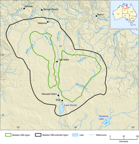
The Beetaloo GBA region is located about 500 km south of Darwin and covers an area of approximately 28,000 km2 in the Northern Territory (Figure 2). It is located entirely in the tropics of the Northern Territory between Katherine and Tennant Creek, with tropical elements in the north and semi-arid elements in the south (Huddlestone-Holmes et al., 2020). The Beetaloo GBA region has been defined specifically for the purposes of the GBA Program as the geological Beetaloo Sub-basin as defined by the Northern Territory Geological Survey (Department of Primary Industry and Resources (NT), 2017).
A broader region, referred to as the ‘Beetaloo GBA extended region’, has also been defined (Figure 2) to match the area of the Northern Territory Government’s Strategic Regional Environmental and Baseline Assessment. This larger region is used to expand additional data discovery and to allow impacts immediately adjacent to the Beetaloo GBA region to be considered. The Strategic Regional Environmental and Baseline Assessment boundary was amended in September 2020 to include the eastern shale depocentre. This change has not been reflected in the Beetaloo GBA extended region and is not included in this assessment.
Surface water systems of the Beetaloo GBA region consist of 5 surface water catchments: the Roper River, Daly River, Limmen Bight River, the Wiso region and the Barkly region (Figure 40 in Huddlestone-Holmes et al. (2020)). The Roper (44%) and Wiso (47%) cover the majority of the region. Most streams in the region are ephemeral and only flow in response to wet-season rains. Groundwater discharge from the Beetaloo GBA region supports the perennial flows in the Roper River downstream of the region through discharge at Mataranka Thermal Pools (Box 2) and baseflow to streams in Elsey National Park.
The landscapes of the Beetaloo GBA region are classified as predominantly loamy and sandy plains with smaller areas of clay plains (Figure 3). Icons in Figure 3 represent stressors on the system that may contribute to an impact due to unconventional gas resource development. A stressor is a physical, chemical or biological agent, environmental condition or external stimulus that might contribute to an impact. The region supports a range of species protected by Australian Government and Northern Territory legislation. Matters of National Environmental Significance that occur, or potentially occur, in the Beetaloo GBA region comprise 14 threatened species, 13 migratory species and one species that is both threatened and migratory. Within the Beetaloo GBA extended region there is potentially one threatened ecological community, 15 threatened species, 15 migratory species an 2 species that are both threatened and migratory. Other protected matters in the Beetaloo GBA extended region comprise 23 listed marine species and 5 areas of Commonwealth lands. Within the Beetaloo GBA region there are 21 listed marine species but no areas of Commonwealth lands.
Among Matters of Territory Environmental Significance, one Territory reserve – Bullwaddy Conservation Reserve – occurs entirely within the Beetaloo GBA region. A further 4 reserves are outside the Beetaloo GBA region but have 100% of their area within the Beetaloo GBA extended region. Also included are 2 nationally important wetlands: Mataranka Thermal Pools and Lake Woods. These occur in the Beetaloo GBA extended region. Four species that are classified as threatened in the Northern Territory (but not nationally) have been recorded in the Beetaloo GBA region since 1990 and are considered likely to still occur there (Pavey et al., 2020).
Prioritisation of these Australian Government and Northern Territory protected matters for this assessment was based on the importance of the Beetaloo GBA extended region to each particular matter (Pavey et al., 2020). The following are assessed as endpoints in the causal network (Section 3): 4 bird species (the Australian painted snipe (Rostratula australis), crested shrike-tit (northern) (Falcunculus (frontatus) whitei), Gouldian finch (Erythrura gouldiae) and grey falcon (Falco hypoleucos)), 1 marsupial (greater bilby (Macrotis lagotis)) and 1 aquatic reptile (Gulf snapping turtle (Elseya lavarackorum)), springs and wetlands.
Among groundwater-dependent ecosystems, springs do not occur within the Beetaloo GBA region but are present within the Beetaloo GBA extended region to the north–north-east and east as discharge complexes from the major northward-flowing groundwater systems of the Cambrian Limestone Aquifer.
Land use within the Beetaloo GBA region is mainly beef cattle production, with perpetual pastoral leasehold covering over 90% of the land area. The region is sparsely populated, with Mataranka, Jilkminggan, Daly Waters and Elliott the most populated settlements, all within the Beetaloo GBA extended region. The Wubalawun, Mangarrayi and Murranji Aboriginal Land Trusts are all partially within the Beetaloo GBA region and the Alawa, Gurungu, Marlinja, Dillinya, Karlantijpa and Mambaliya Rrumburriya Wuyaliya Aboriginal Land Trusts are within, partially within or immediately adjacent to the Beetaloo GBA extended region (Huddlestone-Holmes et al., 2020).

