About the subregion
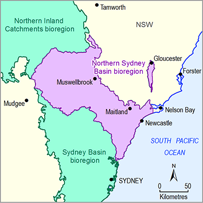
This synthesis presents key findings from the bioregional assessment of the Gloucester subregion, part of the Northern Sydney Basin bioregion.
The subregion, north of the Hunter Valley in NSW, is defined by the geological Gloucester Basin and is home to about 5000 people, mainly in the towns of Gloucester and Stroud. Town water is extracted from local rivers and there are no major dams or wetlands. The majority of the subregion is cleared of native vegetation and supports agricultural uses. The groundwater system is confined within the subregion, so potential impacts on groundwater cannot propagate beyond its boundaries.
A small east-west ridge divides the Avon River catchment in the north from the Karuah river basin in the south. The subregion covers 348 km2; however, the total area investigated in this assessment, the assessment extent, is 481 km2 as it extends along the Karuah and Gloucester rivers beyond the subregion boundaries (Figure 2).
Potential hydrological changes
Hydrological modelling identified potential changes in groundwater and streamflow due to coal resource development for two futures, the baseline and coal resource development pathway (Box 1). The baseline includes two open-cut mines: Duralie Coal Mine in the south, and Stratford Mining Complex in the north. The coal resource development pathway includes the baseline mines plus four additional coal resource developments: mine expansions for the two baseline mines, one new open-cut coal mine at Rocky Hill, north of Stratford, and one coal seam gas (CSG) development, Gloucester Gas Project Stage 1. Note that the Gloucester Gas Project Stage 1 has been withdrawn and in December 2017 the NSW Planning Assessment Commission refused consent for the Rocky Hill Coal Project to proceed.
To rule out impacts on water-dependent ecosystems and assets, a zone of potential hydrological change (Box 4) identified areas where modelling predicted potential changes in surface water and groundwater due to additional coal resource development. The zone comprises 52% of the assessment extent, covers 250 km2 and includes 242 km of streams.
Potential impacts
Cumulative hydrological impacts due to additional coal resource development are predicted to be minor. No impacts on ecological assets are predicted in the south, given the limited additional coal resource development. In the north, potential impacts on ecological assets are expected to be minor and localised due to the relatively small magnitude of predicted hydrological changes.
All 38.4 km2 of the subregion’s estuarine ecosystems are very unlikely to be impacted, along with 7.1 km2 of the total 10.3 km2 of groundwater-dependent ecosystems, and 67 km of the total 344 km of riverine ecosystems.
In the Avon River and Upper Gloucester River, there is a 95% chance that reductions in water availability are less than 1.6 GL per year due to additional coal resource development, which is a 1% to 2% change relative to the baseline.
Modelling suggests that reliability of water supply is very unlikely to be impacted, with no change in cease-to-pump days in the Upper Gloucester River and Karuah River (upper management zone). It is very likely that there will be fewer than 3 additional low-flow days per year in the Avon River, with the impact on cease-to-pump days expected to be smaller.
The greatest confidence in hydrological modelling results is in areas that are very unlikely to be impacted. Where potential impacts are identified, further local-scale modelling may be required to determine the presence and magnitude of ecosystem impacts.
Results are reported for two potential futures: The difference in results between the CRDP and baseline is the change that is primarily reported in a bioregional assessment. This change is due to the additional coal resource development. The CRDP for the Gloucester subregion was based on information available as of October 2015. However, coal resource developments may change over time or be withdrawn, or timing of developments may change. Factors such as climate change and land use were held constant between the two futures. Although actual climate or land use may differ, the effect on results is expected to be minimal as the assessment focused on the difference in the results between the CRDP and baseline, minimising the impacts of changes that occur in both futures.Box 1 Investigating two potential futures

Product Finalisation date
- Executive summary
- Explore this assessment
- About the subregion
- How could coal resource development result in hydrological changes?
- What are the potential hydrological changes?
- What are the potential impacts of additional coal resource development on ecosystems?
- What are the potential impacts of additional coal resource development on water-dependent assets?
- How to use this assessment
- Building on this assessment
- References and further reading
- Datasets
- Contributors to the Technical Programme
- Acknowledgements
- Citation
