- Home
- Impact assessment for the Cooper GBA region (stage 3)
- 2 About the region
- 2.1 Environmental, cultural, social and economic values
The Cooper GBA region ( Figure 2 ) covers approximately 130,000 km2 with 95,740 km2 in Queensland, 34,310 km2 in South Australia and 8 km2 in New South Wales. There are few permanent residents; most of the population is part of the large ‘fly-in–fly-out’ workforce. Major towns include Windorah near the confluence of the Barcoo and Thomson rivers in Queensland, Innamincka to the east of the Ramsar-listed Coongie Lakes wetlands in South Australia, and Moomba, a gas exploration and processing town with no permanent population, to the south of Innamincka in South Australia ( Figure 2 ).
The Cooper GBA region is generally flat, with the braided channels of Cooper Creek flowing from the north-east to the south-west toward Lake Eyre. The climate is hot and dry, with summer-dominated (December to February) rainfall and high inter-annual variability. Most of the region is used to graze sheep and cattle on native vegetation. Smaller areas are used for nature conservation and oil and gas treatment, storage and distribution at Ballera, Jackson and Moomba.
Cooper Creek, which supports the Ramsar-listed Coongie Lakes and many waterholes and terminal lakes, has one of the most variable flow regimes of all rivers worldwide. When flooded, the floodplain becomes a huge inland sea broken only by a few ridges and stunted trees. It contracts in the dry season to channels, lagoons and claypans. Cooper Creek floodplain is more than 60 km wide at its broadest point, stretching east and west of the Innamincka Dome. In this area, Cooper Creek is confined within the rocky and stony walls and steep slopes created by Cooper Creek cutting through the Innamincka Dome (Wakelin-King, 2013).
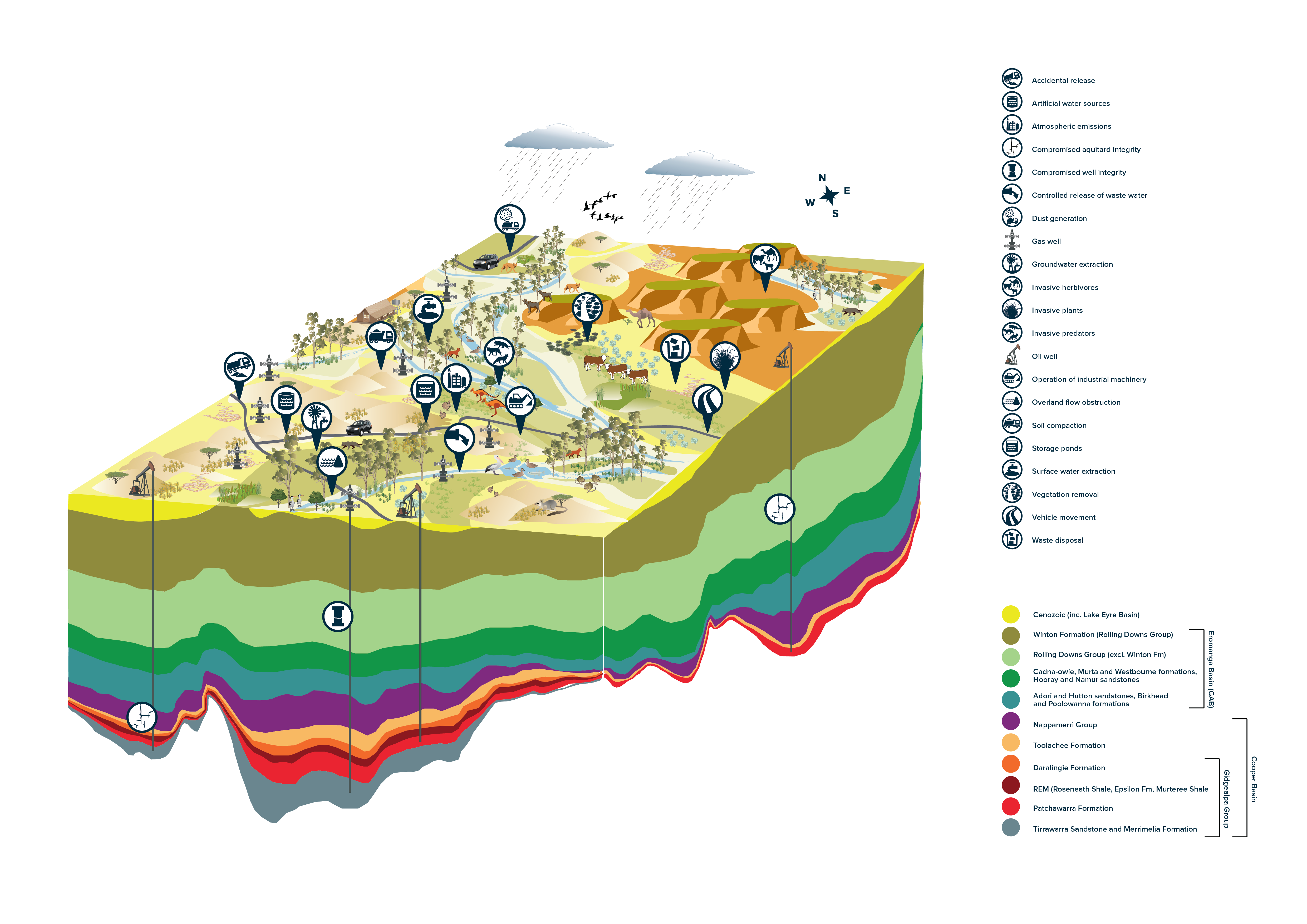
Natural systems in the Cooper GBA region are driven by resource pulses and boom-and-bust ecological dynamics, shaping the high diversity of ecological communities and species ( Figure 3 ). Cooper Creek floodplain is characterised by a hydrologic gradient from the wetter riparian vegetation – including channels, waterholes and fringing vegetation – to the less frequently flooded wetland and floodplain vegetation. The surrounding dryland environment is characterised by gibber plains, low hills, and mesas and high sand dunes with swale wetlands. Icons in Figure 3 represent stressors on the system that may contribute to an impact due to unconventional gas resource development. A stressor is a physical, chemical or biological agent, environmental condition or external stimulus that might contribute to an impact.
Matters of National Environmental Significance (MNES) in the Cooper GBA region include a Ramsar-listed wetland (Coongie Lakes) and the Burke, Wills, King and Yandruwandha National Heritage Place located along the course of Cooper Creek, the one national heritage place listed under the Environment Protection and Biodiversity Conservation Act 1999 (Cth) (EPBC Act) (protected matters technical appendix (O’Grady et al., 2020)). There are also 8 nationally important wetlands (Bulloo Lake; Coongie Lakes; Cooper Creek – Wilson River Junction; Cooper Creek Overflow swamps – Nappa Merrie; Cooper Creek Overflow swamps – Windorah; Lake Cuddapan; Lake Yamma Yamma; and the Strzelecki Creek Wetland system) in the Cooper GBA region. In addition, Queensland and South Australia contain areas reserved for the region’s iconic landforms and biota, important wetlands and groundwater-dependent ecosystems (Section 4.1.2 in baseline synthesis and gap analysis (Holland et al., 2020)).
The Cooper GBA region provides potential habitat for 68 species protected under state or national legislation – 38 birds, 2 fish, 10 mammals, 15 plants and 3 reptiles (protected matters technical appendix (O’Grady et al., 2020)). There are 26 species (plants, reptiles, birds and mammals) listed under the EPBC Act as threatened (critically endangered, endangered or vulnerable). Matters of State Environmental Significance (MSES) in Queensland include 28 species listed as endangered, near threatened, vulnerable or special least concern. In South Australia, 17 species are listed as endangered or vulnerable. The assessment prioritised 12 species (4 birds, 3 mammals and 5 plants) based on the importance of the Cooper GBA region to each species (protected matters technical appendix (O’Grady et al., 2020)).
More than 60% of the region is covered by Indigenous Land Use Agreements and is within the Eyre region for Indigenous language groups. The Cooper GBA region hosts areas of Indigenous and cultural significance. The Register of the National Estate lists 9 Indigenous sites, 12 heritage sites and 2 recreational areas. Cooper Creek and associated waterholes have a long and enduring cultural significance as part of traditional trade routes.
Data: Geoscience Australia (2008); Geological and Bioregional Assessment Program (2020a)
FIGURE 3 Conceptualisation of stressors associated with unconventional gas resource development in the Cooper GBA region

Product Finalisation date
- At a glance
- Explore this assessment
- Executive summary
- 1 About the assessment
- 2 About the region
- 3 Assessment, mitigation and monitoring
- 4 Potential impacts on water
- 5 Potential impacts on the environment
- 6 Potential impacts on protected fauna and flora
- 7 Conclusion
- References
- Glossary
- Contributors to the Program
- Acknowledgments


