- Home
- Factsheets
- Coal resource development and water resources in the Maranoa-Balonne-Condamine subregion

At a glance
Impacts of two proposed coal mines on water resources in the Maranoa-Balonne-Condamine subregion will be limited to small areas near the mines. Most water-dependent assets in the region will be unaffected. Possible impacts on 15 percent of the Barakula State Forest, a small number of bores, and some areas of groundwater-dependent ecosystems and threatened species habitat may require more detailed local investigation, for example, as part of an environmental impact assessment.
What are the coal resource developments?
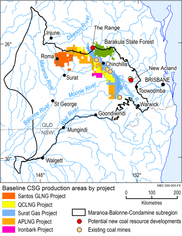
There were five commercially producing open-cut coal mines and five coal seam gas extraction projects at various stages of planning or development in the area when the bioregional assessment process started. One of these existing coal mines closed in 2013. Two potential new coal resource developments were identified as of July 2015: New Acland Stage 3 (an expansion of an existing coal mine) and the The Range (a proposed new coal mine).
What are the potential changes in water?
The assessment focussed on potential changes in water resources as a result of the additional coal resource developments (New Acland Coal Mine Stage 3 and The Range, a proposed open-cut coal mine).
The watertable is very unlikely (less than five percent chance) to fall by more than 0.2 metres due to additional coal resource development, except within 15 kilometres of the New Acland Coal Mine Stage 3 and within 25 kilometres of The Range coal mine. There is at least a five percent chance that the watertable will fall by 0.2 metres or more in a combined area of 1544 square kilometres. The combined area subject to larger falls in the watertable (over five metres) is between two and 10 square kilometres (ninety percent confidence interval).
The watertable is the water level nearest to the surface where the ground is saturated with water. Additional coal resource development can also affect groundwater in deeper geological layers, some of which are accessed by bores. These effects are limited to areas near the mines. For example, the median projected drawdown in the Walloon Coal Measures near the New Acland Coal Mine Stage 3 is 24.9 metres.
Further details on the results can be found in Assessing impacts of coal resource development on water resources in the Maranoa-Balonne-Condamine subregion: key findings (product 5) and Groundwater numerical modelling for the Maranoa-Balonne-Condamine subregion (product 2.6.2).
What might that mean for the landscape and water-dependent assets?
More than 35,000 square kilometres of remnant vegetation, 59,000 kilometres of streams, 1600 square kilometres of wetlands, 177 springs and 93,000 square kilometres of productive land within the assessment extent is very unlikely to be affected by additional coal resource development because it is located in areas where groundwater drawdown will be negligible.
Outside the modelled mine pits, 108 square kilometres of remnant vegetation, 1095 kilometres of streams and two square kilometres of human modified landscapes are both (i) in areas where groundwater has at least a five percent chance of falling by 0.2 metres or more and (ii) potentially groundwater dependent. Further local impact assessment and modelling may be required to understand impacts on these landscapes.
Ninety-four percent (2495 out of 2660) of the water-dependent assets the community nominated are very unlikely to be affected by additional coal resource development because they are in areas where groundwater will fall by less than 0.2 metres. Water-dependent assets located in areas where there is at least a five percent chance that groundwater will fall by at least 0.2 metres include 163 water bores, 15 percent of the Barakula State Forest, and potential habitats of four threatened ecological communities, and 27 threatened species (18 listed under Commonwealth and 11 under Queensland legislation). These assets may be affected by additional coal resource development. Drawdown is very likely to exceed five metres in 17 of the 163 water bores referred to above, all of them near the New Acland Stage 3 coal mine.
Further details on the results can be found in Assessing impacts of coal resource development on water resources in the Maranoa-Balonne-Condamine subregion: key findings (Outcome Synthesis). More specific information on the impacts including the sensitivity of different landscape classes to hydrological change can be found in the Impact and risk analysis for the Maranoa-Balonne-Condamine subregion (product 3-4).
How was the assessment done?
Scientists used the best available data to describe coal and coal seam gas resources, and to assess potential changes to groundwater due to proposed new coal resource developments.
Queensland’s Office of Groundwater Impact Assessment (OGIA) groundwater model was adapted for this assessment to predict the potential cumulative impacts of current and future coal resource development. Ecosystems in the region were classified into five landscape groups (including 34 landscape classes) based on their likely response to groundwater drawdown and associated changes in surface flows. Potential impacts on and risks to ecosystems were analysed by overlaying the extent of the landscape groups on groundwater drawdown.
Local experts, including councils, natural resource management groups and community groups, provided information on local water-dependent assets, such as wetlands and bores, that rely on surface water or groundwater. A register of these assets is available for use in future assessments.
How will information from the assessment be used?
The data and tools from this assessment are available to support natural resource management in the Maranoa-Balonne-Condamine subregion. They can be used in future assessments and environmental studies.
Results from this assessment are provided in eight reports, a water-dependent asset register and a data register at www.bioregionalassessments.gov.au/assessments/Maranoa-Balonne-Condamine-subregion. The website provides open access to the methods and datasets used to develop the assessment. Data from a range of disciplines are provided under a Creative Commons Attribution license where possible on the Australian Government’s public data information service www.data.gov.au.

The Maranoa-Balonne-Condamine subregion covers 144,890 square kilometres and is mainly within the Queensland part of the Murray–Darling Basin, with a small area in New South Wales. It is part of the Northern Inland Catchments bioregion.
